🇱🇾

Libya

Africa • Countries
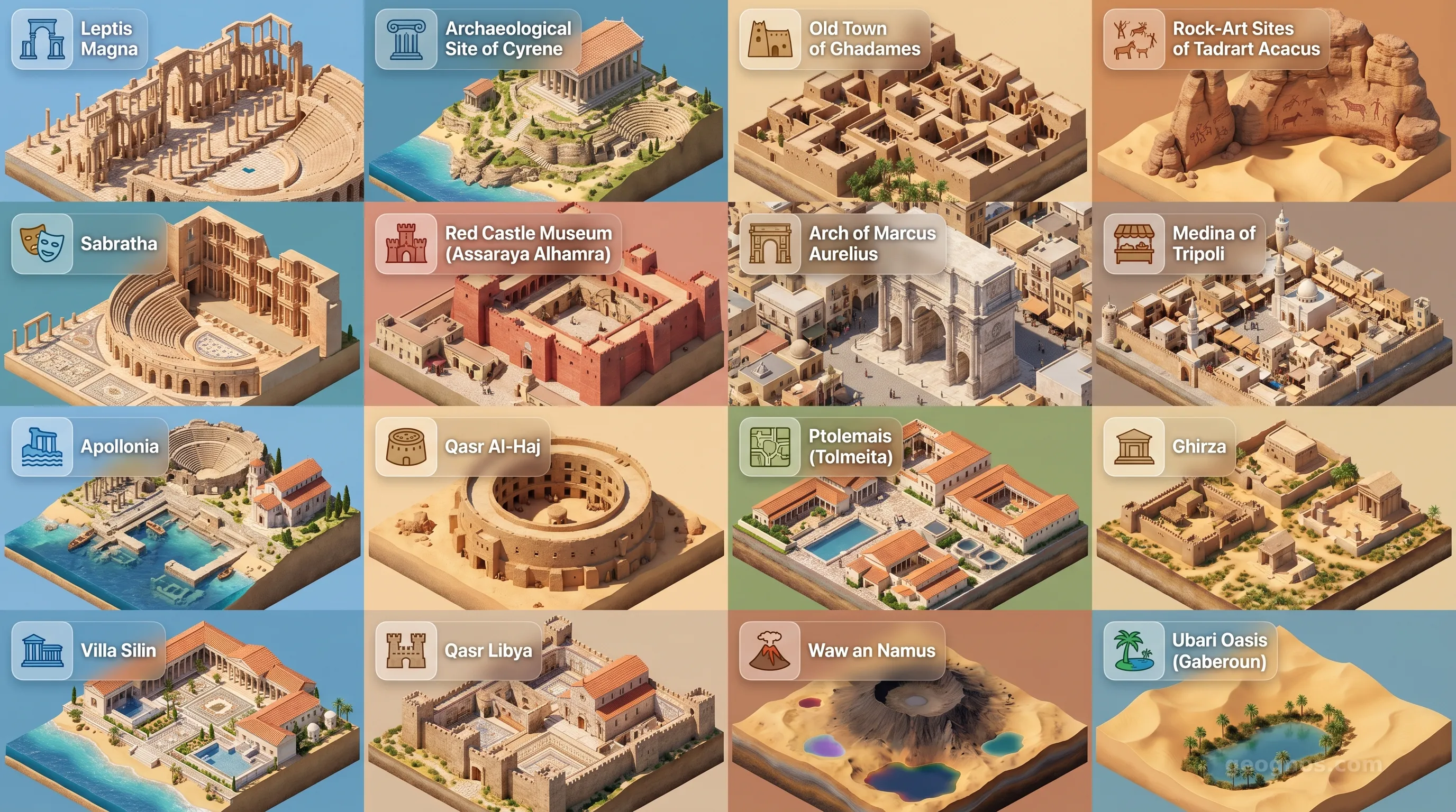
Libya - Panoramic Places of Interest Atlas including Leptis Magna, Archaeological Site of Cyrene, Old Town of Ghadames, Rock-Art Sites of Tadrart Acacus, Sabratha, Red Castle Museum (Assaraya Alhamra), Arch of Marcus Aurelius, Medina of Tripoli, Apollonia, Qasr Al-Haj, Ptolemais (Tolmeita), Ghirza, Villa Silin, Qasr Libya, Waw an Namus, Ubari Oasis (Gaberoun)

Top Sights & Landmarks

01

Leptis Magna

The Jewel of Roman Africa

02

Archaeological Site of Cyrene

The Athens of Africa

03

Old Town of Ghadames

The Pearl of the Desert

04

Rock-Art Sites of Tadrart Acacus

Prehistoric Desert Canvas

05

Sabratha

Coastal Roman Splendor

06

Red Castle Museum (Assaraya Alhamra)

Tripoli's Historical Fortress

07

Arch of Marcus Aurelius

Tripoli's Roman Gateway

08

Medina of Tripoli

The Walled Old City

09

Apollonia

The Sunken Greek Port

10

Qasr Al-Haj

Ancient Berber Granary

11

Ptolemais (Tolmeita)

The Hellenistic Capital

12

Ghirza

Romano-Libyan Fortified Settlement

13

Villa Silin

Luxurious Seaside Roman Villa

14

Qasr Libya

Byzantine Mosaic Treasure

15

Waw an Namus

The Oasis of Mosquitoes

16

Ubari Oasis (Gaberoun)

Saharan Lakes of the Sand Sea

The Silent Sentinels of the Sahara

To stand upon the Mediterranean shore of Libya is to stand at the edge of two worlds. Before you lies the cerulean expanse of the sea, the historic corridor of the Phoenicians, Greeks, and Romans. Behind you, stretching toward the horizon, lies the vast, shifting heart of the Sahara. Libya is not merely a country of borders or administrative maps. It is a profound dialogue between the moisture-laden winds of the North and the timeless, golden silence of the Great Sand Sea. This geographical duality has defined the soul of the region for millennia, turning Libya into an essential vault of human memory.

For the modern observer, Libya offers a rare perspective on the longevity of civilization. It is a landscape where the Roman amphitheaters of Leptis Magna seem to hold their breath, waiting for a crowd that departed ages ago, while the desert winds continue to carve intricate patterns into the ancient rock art of the Tadrart Acacus. Here, history is not buried beneath layers of modern development; it remains accessible, a skeletal architecture of empires that rose and fell on the cusp of the arid interior.

A Crossroads of Ancient Mediterranean Currents

Libya has served as a bridge, a port, and a barrier. Because of its expansive coastline, it became the natural gateway to the African continent for maritime explorers from Europe. Whether one examines the cultural synthesis of the Cyrenaica region or the Berber traditions embedded deep within the mountain ranges of the Nafusa, the nation acts as a prism through which diverse human legacies are refracted. To understand how these disparate influences coalesced into the Libyan identity, one must first look at the timeline of its development.

For those seeking to delve into the narrative arch of this North African nation, our detailed history essay provides a deep dive into the successive waves of influence, from the ancient Garamantes to the subsequent eras of coastal urbanization. The complexity of these periods can be quite dense, which is why we encourage both students and history enthusiasts to test their knowledge of the timeline. If you wish to challenge yourself or your class, try solving our interactive history puzzle to earn your badges as you master the chronology of Libya’s rise.

Visualizing the Echoes of Antiquity

History, however, is best felt when it is brought to life through sight and sequence. The geography of Libya is punctuated by sites of immense cultural weight. From the remarkably preserved Roman ruins to the mysterious rock carvings found deep in the southern desert, these markers signify a deep connection to our shared human origin. We invite you to experience the emotional depth of these timelines through our history cinematic showcase, a carefully curated sequence that brings the major eras of the country into clear view through archival imagery and narrative summaries.

Furthermore, Libya offers a sensory landscape unlike anywhere else on the planet. The stark beauty of its oases and the silent, stone-wrought grandeur of its UNESCO World Heritage sites represent a physical archive of humanity. You can get an intimate look at the visual majesty of these locations in our POI cinematic showcase. This visual tour highlights the iconic landscapes, from the palm-fringed wonders of Ghadames to the wind-swept ruins of Sabratha, serving as both a guide for prospective travelers and a teaching tool for the global classroom.

The Geography of Resilience

The Libyan environment is perhaps the most resilient protagonist in this story. The northern strip, dominated by the Mediterranean climate, has always been a sanctuary for agriculture and settlement. Yet, the vast majority of the land mass is claimed by the desert, a space that requires immense ingenuity for survival. The traditional subterranean architecture of the Nafusa Mountains and the complex irrigation techniques perfected by ancient societies in the heart of the Sahara highlight a sophisticated understanding of geography. It is this interaction with the desert that continues to inspire current studies in archaeology and climatology.

As we examine the geography of Libya, we find a nation of profound contrasts. The mountains, though rugged and imposing, act as water catchments for the valleys below, while the coastal plains offer fertile soil that once fed the grain-hungry coffers of Rome. Educators and students are invited to examine the relationship between these natural features and the historical density of the coastal cities. In our upcoming sections on this page, we will analyze the geological features, the economic importance of the Sahara as an energy reservoir, and the demographic shifts that have formed the modern Libyan society.

Bridging Yesterday and Tomorrow

The mission of GeoGnos is to peel back the layers of geography to reveal the people and the stories that dwell within them. Libya, with its dramatic interplay between the arid, expansive South and the vibrant, historic North, serves as one of the most compelling chapters in our atlas. By exploring these landmarks, both real and historical, we cultivate a deeper sense of empathy and a broader understanding of the endurance of civilization.

Whether you are a researcher, a K-12 educator planning a curriculum unit, or a curious traveler, Libya invites you to witness the enduring dialogue between humanity and the land. As you browse the following sections detailing the economy, the political governance, and the environmental landscape, remember that each fact exists within the context of a landscape that has been navigated for thousands of years. From the vast, unpopulated tracts of the desert to the bustling energy of Tripoli, Libya remains a pillar of North African cultural heritage, offering lessons in persistence, adaptation, and the quiet dignity of a land that refuses to be forgotten.
Location

Latitude
25° N
Longitude
17° E
N S W E
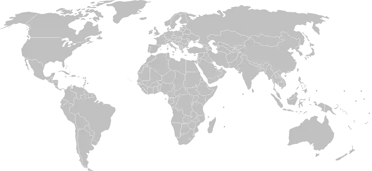
World Map Location
Geographic Location

Northern Africa, bordering the Mediterranean Sea, between Egypt, Tunisia, and Algeria

Map Reference
Africa

Area

Total Area
1,759,540 sq km
Land (100%)
Land: 1,759,540 sq km
Water: 0 sq km

Elevation

Highest Point
Bikku Bitti
Bikku Bitti 2,267 m
Lowest Point
Sabkhat Ghuzayyil
Sabkhat Ghuzayyil -47 m
Mean Elevation
423 m

Detailed Geography Information

Coastline

1,770 km

Geography - note

note 1: more than 90% of the country is desert or semidesert note 2: the volcano Waw an Namus lies in south central Libya in the middle of the Sahara; the caldera is an oasis -- the name means "oasis of mosquitoes" -- containing several small lakes that host many species of insects and birds

Irrigated land

4,700 sq km (2012)

Land boundaries

Total boundary: 4,339 km
Algeria 989 km
Chad 1050 km
Egypt 1115 km
Niger 342 km
Sudan 382 km
Tunisia 461 km

Major aquifers

Nubian Aquifer System, North Western Sahara Aquifer System, Murzuk-Djado Basin

Major watersheds (area sq km)

Internal (endorheic basin) drainage: Lake Chad (2,497,738 sq km)

Maritime claims

territorial sea: 12 nm exclusive fishing zone: 62 nm note: Gulf of Sidra closing line - 32 degrees, 30 minutes north

Natural hazards

hot, dry, dust-laden ghibli is a southern wind lasting one to four days in spring and fall; dust storms, sandstorms

Natural resources

petroleumnatural gasgypsum

Terrain

mostly barren, flat to undulating plains, plateaus, depressions

Population & Growth

+1.40% Growth
7,464,417
Total inhabitants (2025 est.)
Male: 50.8% (3,792,617) Female: 49.2% (3,671,800)

Age Distribution

0-14 years
32.3%
~2,411,007
15-64 years
63.2%
~4,717,512
65 years
4.6%
~343,363
Note: 2024 est.

Demographic Longevity

Median Age
26.4 years
Male
26.3 yrs
Female
26.2 yrs
Life Expectancy
77.7 years
Male
75.5 yrs
Female
80 yrs

Vital Dynamics

Birth Rate
19.83
births per 1,000 people
Death Rate
3.48
deaths per 1,000 people
Net Migration
-2.89
migrants per 1,000 people
Fertility Rate
2.96
children born per woman

Detailed People & Society Information

Alcohol consumption per capita

0.01 liters of pure alcohol (2019 est.)

Children under the age of 5 years underweight

4.3% (2022 est.)

Dependency ratios

total dependency ratio: 57.3 (2025 est.) youth dependency ratio: 49.8 (2025 est.) elderly dependency ratio: 7.5 (2025 est.) potential support ratio: 13.4 (2025 est.)

Ethnic groups

Amazigh and Arab
97%
other (includes Egyptian
3%

Gross reproduction rate

1.44 (2025 est.)

Health expenditure

5.1%

5.1% of national budget (2022 est.)

Hospital bed density

3.2 beds/1,000 population (2021 est.)

Infant mortality rate

total: 10.4 deaths/1,000 live births (2025 est.) male: 12.1 deaths/1,000 live births female: 9.3 deaths/1,000 live births

Languages

Major urban areas - population

1.183 million TRIPOLI (capital), 984,000 Misratah, 859,000 Benghazi (2023)

Maternal mortality ratio

59 deaths/100,000 live births (2023 est.)

Nationality

noun: Libyan(s) adjective: Libyan

Obesity - adult prevalence rate

32.5% (2016)

Physician density

2.04 physicians/1,000 population (2017)

Population distribution

over 90% of the population lives along the Mediterranean coast in and between Tripoli to the west and Al Bayda to the east; the interior remains vastly underpopulated due to the Sahara and its lack of surface water, as shown in this population distribution map

Refugees and internally displaced persons

Total Displaced & Vulnerable Persons
416,315 individuals
Refugees
66.5%
277,010
277,010 (2024 est.)
Internally Displaced Persons (IDPs)
33.5%
139,305
139,305 (2024 est.)

Religions

Muslim
96.6%
Christian
2.7%
Buddhist <
1%
Hindu <
1%
Jewish <
1%
folk religion <
1%
other <
1%
unaffiliated <
1%

Sex ratio

at birth: 1.05 male(s)/female 0-14 years: 1.04 male(s)/female 15-64 years: 1.05 male(s)/female 65 years and over: 0.82 male(s)/female total population: 1.04 male(s)/female (2024 est.)

Climate & Issues

Climate Profile

Mediterranean along coast; dry, extreme desert interior

Key Environmental Issues
desertification limited natural freshwater resources water pollution threats to coastal ecosystem from sewage, oil byproducts, and industrial waste

Land Cover

Coverage Distribution
Other (91%)
Arable: 1.0%
Crops: 0.2%
Pasture: 7.6%
Forest: 0.1%

Air & Carbon Emissions

Annual CO2 Output 2023 est.
46.479 million
Coal (94%) Oil (4%) Gas (2%)
PM2.5 Exposure 29.8 µg/m³
0 5 (WHO Limit) 15 25 35+
Methane Emissions
energy: 1,357.4 kt (2022-2024 est.)

Water Resources & Use

Renewable Water Resources 700 million cubic meters (2022 est.)
Annual Water Withdrawal
municipal: 700 million cubic meters (2022 est.)
Municipal (12%) Ind (5%) Agri (83%)

Detailed Environmental Information

International environmental agreements

BiodiversityClimate ChangeClimate Change-Kyoto ProtocolComprehensive Nuclear Test BanDesertificationEndangered SpeciesHazardous WastesMarine Dumping-London ConventionNuclear Test BanOzone Layer ProtectionShip PollutionWetlands

Urbanization

urban population: 81.6% of total population (2023) rate of urbanization: 1.45% annual rate of change (2020-25 est.)

Waste and recycling

municipal solid waste generated annually: 2.148 million tons (2024 est.)

Capital & State Profile

Capital City
Tripoli
32.8833° N, 13.1667° E
Timezone UTC+2
Government Type
in transition
Independence 1951-12-24
National Holiday 10-23

Executive Branch

Chief of State
President, Presidential Council, Mohammed al-MANFI (since 5 February 2021)
Head of Government
GNU Interim Prime Minister Abd-al-Hamid DUBAYBAH (since 5 February 2021)
Last Election scheduled for 24 December 2021 but not held
Next Election no new date has been set for elections

Legislative Branch

unicameral
Seats & Term
200 (all directly elected) seats / N/A
Women in Chamber
16.5% Representation
Electoral System other systems

National Identity & Symbols

National Flag Description

three horizontal bands of red (top), black (double-width), and green, with a white crescent and star centered on the black stripe

Symbolic Meaning the colors represent the three major regions of the country: red stands for Fezzan, black for Cyrenaica, and green for Tripolitania; the crescent and star represent Islam
National Symbol star and crescent, hawk
National Colors red, black, green
National Anthem Libya, Libya, Libya

Detailed Government Information

Administrative divisions

22 governorates (muhafazah, singular - muhafazat); Al Butnan, Al Jabal al Akhdar, Al Jabal al Gharbi, Al Jafarah, Al Jufrah, Al Kufrah, Al Marj, Al Marqab, Al Wahat, An Nuqat al Khams, Az Zawiyah, Banghazi (Benghazi), Darnah, Ghat, Misratah, Murzuq, Nalut, Sabha, Surt, Tarabulus (Tripoli), Wadi al Hayat, Wadi ash Shati

Citizenship

citizenship by birth: no citizenship by descent only: at least one parent or grandparent must be a citizen of Libya dual citizenship recognized: no residency requirement for naturalization: varies from 3 to 5 years

Constitution

history: previous 1951, 1977, 2011 (interim) note: a draft constitution was approved in 2017, but it is not yet ratified

Country name

conventional long form: State of Libya conventional short form: Libya local long form: Dawlat Libiya local short form: Libiya etymology: the name probably derives from the Libu, a North African tribe first mentioned in texts from the 13th century B.C.; the ancient Greeks and Romans used the name for the entire North African coast west of Egypt

International law organization participation

has not submitted an ICJ jurisdiction declaration; non-party state to the ICCt

International organization participation

Judicial branch

highest court(s): Libya's judicial system consists of a supreme court, central high courts (in Tripoli, Benghazi, and Sabha), and a series of lower courts

Legal system

Libya's post-revolution system is in flux and driven by state and non-state entities

National heritage

total World Heritage Sites: 5 (all cultural) selected World Heritage Site locales: Archaeological Site of Cyrene; Archaeological Site of Leptis Magna, Archaeological Site of Sabratha; Rock-Art Sites of Tadrart Acacus; Old Town of Ghadam&egrave;s

Suffrage

18 years of age, universal

Economic Overview

upper middle-income, fossil fuel-based North African economy; 31% economic contraction due to COVID-19 and 2020 oil blockade; reduced government spending; central bank had to devalue currency; public wages are over 60% of expenditures

Size & Performance

Real GDP (PPP)
$90.609 billion
Latest available estimate (2024)
2023: $91.161 billion2022: $82.756 billion
Real GDP Growth
-0.6% (2024 est.)
-0.6%
GDP Per Capita (PPP)
$12,300
2023: $12,5002022: $11,500

GDP Sector Breakdown

Agriculture: 1.7%Industry: 68.3%Services: 34.3%
Origin GDP %
Agriculture 1.7%
Industry 68.3%
Services 34.3%

Trade Balance

Trade Position
Trade Surplus
$4.47 billion
Total Exports
$37.753 billion (2023 est.)
Total Imports
$33.284 billion (2023 est.)
Exports (53%) Imports (47%)

Budget Balance

Budget Position
Budget Deficit
-$9.47 billion
Revenues
$28.005 billion (2019 est.)
Expenditures
$37.475 billion (2019 est.)
Revenues (43%) Expenditures (57%)

Export Profile

Top Export Partners

23.0%
9.0%
6.0%
Note: 2023; top five export partners based on percentage share of exports

Major Export Commodities

crude petroleumnatural gasrefined petroleumgoldscrap iron

Import Profile

Top Import Partners

17.0%
15.0%
8.0%
8.0%
8.0%
Note: 2023; top five import partners based on percentage share of imports

Major Import Commodities

refined petroleumbroadcasting equipmenttobaccogarmentscars

Labor & Employment

Total Labor Force 2.585 million (2024 est.)
General Unemployment Rate 18.7%
Youth Unemployment (Ages 15-24) 49.5%

Income Inequality

Detailed Economic Data

Agricultural products

potatoesonionswatermelonstomatoesdatesolivesmilkchickenwheatvegetables

Current account balance

$1.865 billion (2023 est.) $9.607 billion (2022 est.) $5.675 billion (2021 est.) note: balance of payments - net trade and primary/secondary income in current dollars

Exchange rates

Libyan dinars (LYD) per US dollar - Exchange rates: 4.832 (2024 est.) 4.813 (2023 est.) 4.813 (2022 est.) 4.514 (2021 est.) 1.389 (2020 est.)

GDP - composition, by end use

Industrial production growth rate

-5.8% (2024 est.) note: annual % change in industrial value added based on constant local currency

Industries

petroleumpetrochemicalsaluminumiron and steelfood processingtextileshandicraftscement

Inflation rate (consumer prices)

2.1% (2024 est.) 2.4% (2023 est.) 4.5% (2022 est.) note: annual % change based on consumer prices

Remittances

0% of GDP (2023 est.) 0% of GDP (2022 est.) 0% of GDP (2021 est.) note: personal transfers and compensation between resident and non-resident individuals/households/entities

Reserves of foreign exchange and gold

$92.894 billion (2024 est.) $92.427 billion (2023 est.) $86.683 billion (2022 est.) note: holdings of gold (year-end prices)/foreign exchange/special drawing rights in current dollars

Grid Infrastructure

Electricity Access 70%
Urban: 100%
Capacity 10.519 million kW (2023 est.)
Consumption 28.826 billion kWh (2023 est.)
Imports 800 million kWh (2023 est.)
Grid Losses: 7.081 billion kWh (2023 est.)

Generation Mix

Percentage Share of Production
fossil fuels 100%

Fossil Fuels Production

Petroleum
Production 1.245 million bbl/day (2023 est.)
Consumption 207,000 bbl/day (2023 est.)
Proven Reserves 48.363 billion barrels (2021 est.)
Natural Gas
Production 11.16 billion cubic meters (2023 est.)
Consumption 8.633 billion cubic meters (2023 est.)
Exports 2.527 billion cubic meters (2023 est.)
Proven Reserves 1.505 trillion cubic meters (2021 est.)
Coal
Imports 4,000 metric tons (2023 est.)

Intensity & Nuclear

Energy Consumption Per Capita 100.844 million Btu/person (2023 est.)
No nuclear energy infrastructure or reactor operations reported in this country dossier.

Digital Access

.ly
Internet Usage 89%

Active internet users as a percentage of the total population.

Fixed Broadband

Penetration Rate 5 / 100
Total Subscriptions 326,000 (2022 est.)

Mobile Cellular

Penetration Rate 193 / 100
Total Subscriptions 13.9 million (2022 est.)

Broadcast Media

state-funded and private TV stations; some provinces operate local TV stations; pan-Arab satellite TV stations are available; state-funded radio (2019)

Aviation

5A
Airports
75
As of 2025

Ports & Harbors

Ports Count 14
Hover for breakdown & key ports As of 2024

Merchant Marine

Commercial Fleet
96 ships
Hover for vessel types breakdown As of 2023

Military Expenditures

GDP Allocation N/A
not available

Active Duty Strengths

estimates not available

Refers to active military personnel.

Service & Defense Details

Military and security forces

the Libyan Armed Forces of the Tripoli-based Government of National Unity (GNU) have various ground, air, and naval/coast guard forces, which include a mix of nominally integrated and semi-regular units, tribal armed groups and militias, civilian volunteers, and foreign military contractors; the GNU's armed forces are nominally under the control of the Ministry of Defense; the GNU also has various internal security forces under both the Ministry of Defense and the Ministry of Interior (2025) note: the self-styled Libyan National Army (LNA; aka Libyan Arab Armed Forces, LAAF) under Khalifa HAFTER also includes various ground, air, and naval/coast guard forces comprised of semi-regular military personnel, militias, other armed groups, and foreign military contractors; some of the armed units nominally under the LNA operate under their own command structures and engage in their own operations

Military equipment inventories and acquisitions

both the forces aligned with the GNU and the LNA are largely equipped with weapons of Russian or Soviet origin; in recent years, T&uuml;rkiye has the been the primary supplier of arms to the GNU, while the LNA has received quantities from Russia and the United Arab Emirates (2025) note: Libya is under a UN-imposed arms embargo

Military - note

the western-based forces aligned with the GNU and the eastern-based LNA forces are separated by a fortified line of control just west of the coastal city of Sirte; Turkey has provided support to the GNU forces, including military trainers, ammunition, weapons, and aerial drones; Russia, the United Arab Emirates, and Egypt have been the main supporters of the LNA (2025)

Military service age and obligation

not available