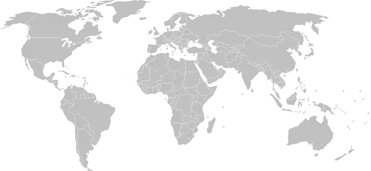
The Lonely Sentinel of the Central Pacific
Rising abruptly from the sapphire depths of the Pacific Ocean, a mere 42 kilometers south of the equator, Nauru presents a silhouette unlike any other. It is not an archipelago of scattered coral fragments, but a singular, jagged limestone crown perched upon an ancient seamount. To approach Nauru by air is to witness a profound testament to the power of geologic time. The island is an isolated geological monolith, a small circle of land encompassing only 21 square kilometers, yet it carries a weight of history and biological significance that far transcends its modest dimensions.
For the traveler, the educator, and the curious scholar, Nauru is a case study in extremes. It is the smallest island nation in the world and the smallest independent republic. Here, the landscape is defined by the duality of the coastal "Ring of Life," where the island's small population resides amidst coconut palms and white-sand beaches, and the interior "Topside," a stark, lunar landscape shaped by eons of avian presence and later, intensive human industry. Understanding this topography is key to unlocking the true essence of this Micronesian treasure, a place that continues to demonstrate resilience in the face of immense environmental transition.
A Testament to Time and Transformation
Nauru has always been a beacon in the vast expanse of the Pacific. Its isolation did not render it stagnant but rather created a unique cradle for human culture and natural processes. For those looking to understand the forces that built this nation from the ocean floor upward, the comprehensive history of Nauru provides an essential academic foundation. From the arrival of the original Polynesian and Micronesian seafarers, who mastered the currents to reach these remote shores, to the complex developments of the modern era, the island’s story is one of profound adaptation.
Students and teachers alike often find the chronological evolution of this nation both challenging and fascinating. Because Nauru has occupied such a specific role in global maritime trade and resource history, keeping track of its pivotal dates is a rewarding exercise. We invite you to test your mastery of these timelines with our interactive history puzzle of Nauru. By placing key events in their proper sequence, you will earn badges that celebrate your deep dive into the island's past, transforming facts into a coherent narrative of survival and sovereign identity.
The Living Tapestry of the Landscape
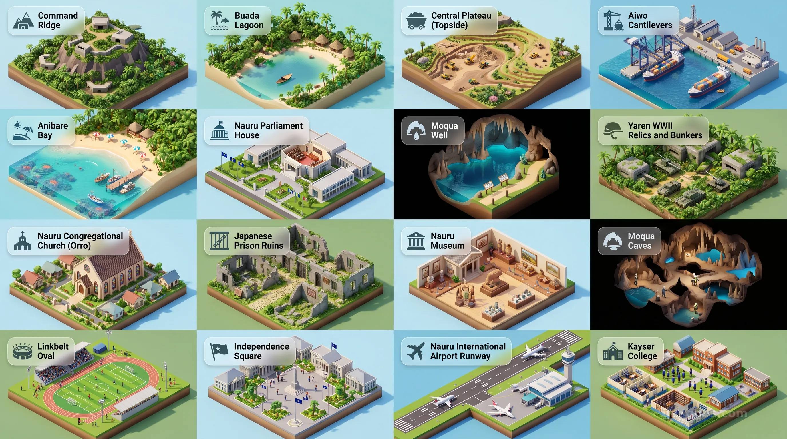
Beyond the administrative centers and the history books, Nauru reveals itself in color, shadow, and salt spray. The coastal perimeter—the belt where Nauru truly breathes—is a mosaic of traditional culture and tranquil beauty. Visitors are often captivated by the remnants of the island’s natural beauty that persist despite its intense history. To gain a true appreciation for the visual splendor that awaits those who venture to this part of the world, our cinematic showcase of Nauruan history offers an immersive, frame-by-frame journey through the events that defined the island's evolution. Through a collection of meticulously curated illustrations and summary descriptions, the past comes to life, illustrating the transformation of the landscape with academic clarity and artistic grace.
If your interests lean more toward the natural beauty and the subtle points of intrigue found on the island today, we suggest you engage with our cinematic tour of Nauru's top points of interest. This feature allows you to experience the island’s diverse geography—from the rocky, weathered pinnacles of the interior to the serene turquoise lagoons—all from the convenience of a high-fidelity carousel player. It is a visual catalog designed for the modern classroom and the aspiring explorer, ensuring that the geographic identity of Nauru is understood not just as a set of statistics, but as a living, breathing place.
The Cultural Soul of the Central Pacific
The spirit of Nauru is profoundly rooted in its small, tightly knit community. The people of Nauru maintain a vibrant heritage, reflecting a deep respect for the maritime environment that has surrounded them for generations. Life here is influenced by a rhythm dictated by the sun and the sea, characterized by an enduring communal structure. As educators at GeoGnos, we strive to portray this nation not through the lens of fleeting news headlines, but through the enduring lens of its cultural dignity. Whether it is the gathering of family on the beaches during sunset or the celebration of national holidays that reflect deep-seated Micronesian traditions, there is a steady pulse of identity here that persists.
As you navigate this page, we encourage you to look deeper into the geological and demographic facets that follow. Consider how the island’s unique topography dictates its economy and how its isolation informs its communications. By synthesizing this information, one begins to see Nauru for what it truly is: a singular, resilient entity that occupies a vital space in the global geographic consciousness. It is a testament to the fact that greatness, in historical and human terms, is not a product of sheer size, but of the depth of one’s connection to the land and the shared story of its people.
As you continue your exploration through the remaining sections on the Nauruan government, climate, and modern economic structure, remember the narrative arc we have traced today. Nauru remains a fascinating study in environmental impact, historical significance, and human adaptability. It invites us all to pause and contemplate our own relationship with the earth, reminding us that every kilometer, no matter how small, is a repository of vital knowledge and infinite human value.