🇬🇶

Equatorial Guinea

Africa Countries
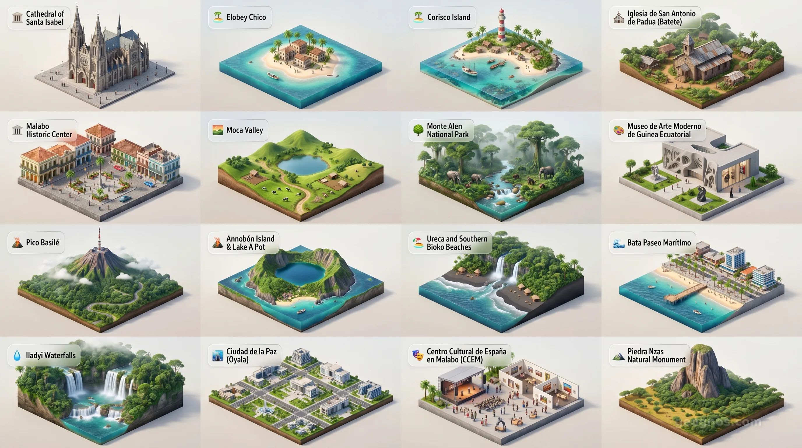
Equatorial Guinea - Panoramic Places of Interest Atlas including Cathedral of Santa Isabel, Elobey Chico, Corisco Island, Iglesia de San Antonio de Padua (Batete), Malabo Historic Center, Moca Valley, Monte Alen National Park, Museo de Arte Moderno de Guinea Ecuatorial, Pico Basilé, Annobón Island & Lake A Pot, Ureca and Southern Bioko Beaches, Bata Paseo Marítimo, Iladyi Waterfalls, Ciudad de la Paz (Oyala), Centro Cultural de España en Malabo (CCEM), Piedra Nzas Natural Monument

Top Sights & Landmarks

01

Cathedral of Santa Isabel

Iconic Spanish Gothic Cathedral

02

Elobey Chico

Abandoned Colonial Island Capital

03

Corisco Island

Ancient Mission and Pristine Sands

04

Iglesia de San Antonio de Padua (Batete)

Historic Wooden Gothic Church

05

Malabo Historic Center

Spanish Colonial Heart of the Capital

06

Moca Valley

Cultural Heartland of the Bubi People

07

Monte Alen National Park

Untouched Equatorial Rainforest

08

Museo de Arte Moderno de Guinea Ecuatorial

Hub of Contemporary Guinean Art

09

Pico Basilé

Sacred Volcanic Summit

10

Annobón Island & Lake A Pot

Isolated Volcanic Crater Lake

11

Ureca and Southern Bioko Beaches

Turtle Nesting and Untamed Coastlines

12

Bata Paseo Marítimo

Coastal Promenade of the Economic Capital

13

Iladyi Waterfalls

Bioko's Spectacular Cascades

14

Ciudad de la Paz (Oyala)

The Futuristic Jungle Capital

15

Centro Cultural de España en Malabo (CCEM)

Epicenter of Guinean-Spanish Culture

16

Piedra Nzas Natural Monument

Sacred Monolithic Rock Formation

The African Paradox of Equatorial Guinea

Equatorial Guinea occupies a singular space on the global map, both literally and figuratively. Nestled in the corner of the Gulf of Guinea, it is a nation defined by a profound geographical dichotomy: a jagged, continental territory carved from tropical rainforests, and a collection of verdant islands scattered like volcanic jewels in the Atlantic Ocean. To study this nation is to engage with a study of contrasts, where ancient equatorial biodiversity meets the currents of shifting geopolitical tides. It is a place where the air hangs heavy with the scent of sea salt and orchids, and where the story of humanity has been etched into the very soil by centuries of exploration, adaptation, and resilient transformation.

For the traveler or the scholar, understanding the soul of this nation requires looking beyond the coast. It is a country that stands as the only sovereign African nation where Spanish is an official language, acting as a bridge between the vibrant heritage of the continent and the legacy of the Hispanic world. This unique intersection informs every aspect of local culture, from the rhythms of the music to the culinary fusion found in the bustling markets of Malabo. To understand how these disparate elements coalesced into the identity we see today, one should explore the history of Equatorial Guinea, which chronicles the journey from pre-colonial tribal kingdoms to the diverse cultural tapestry that defines the modern state.

The Geography of Two Worlds

Unlike many of its neighbors, the structure of Equatorial Guinea is bifurcated. The mainland, known as Rio Muni, sits firmly between Cameroon and Gabon, defined by rolling plateaus, lush river valleys, and a climate of enduring, humid warmth. In contrast, the island region, most notably Bioko, rises from the Atlantic with the formidable silhouette of volcanic peaks. These islands are remnants of fiery origins, fertile and dramatic, creating a landscape that challenges the eye and inspires the imagination. The sheer ecological diversity here is staggering, providing habitats for some of the most elusive and captivating wildlife found within the Congo Basin and the coastal shelf.

The interaction between the people and this land is an ongoing narrative of stewardship and discovery. If you wish to witness how this rugged beauty has been cataloged and captured through a traveler’s lens, you can browse through the POI Cinematic Showcase, which highlights the breathtaking peaks, pristine beaches, and architectural remnants of this distinct corner of West Africa.

A Heritage Etched in Time

The history of Equatorial Guinea is not merely a sequence of dates, but a complex mosaic of cultural blending and endurance. From the ancestral wisdom of the Bubi and Fang peoples to the arrival of European explorers who reshaped the colonial administrative maps, the nation has evolved into a resilient state that proudly claims its unique place in the community of nations. Educators and students alike often find that the best way to comprehend this timeline is through active engagement. For those looking to master the chronology of this land, we invite you to participate in the History Puzzle, an interactive journey where arranging key moments correctly will earn you badges for your GeoGnos portfolio.

Visual learners may find it even more illuminating to see these eras brought to life. Our History Cinematic Showcase offers an immersive experience, allowing you to walk through the major events of the past century through vivid illustrations and narrative summaries. These milestones, ranging from the arrival of early explorers to the dawn of sovereignty, paint a picture of a nation that has spent centuries refining its own voice, ensuring that its cultural heritage remains distinct amidst a changing global landscape.

The Essence of the Gulf

What makes Equatorial Guinea truly stand out on a world atlas is its quiet tenacity. It does not shout its presence, but rather invites the observant visitor to step into a rhythm that is distinctly Equatorial Guinean. Whether it is the dense canopy of the Monte Alén National Park or the historic colonial-era architecture that colors the streets of the capital, there is a consistent theme of transformation. The nation serves as a reminder that history is never static. It is a living, breathing process of growth that occurs in the shadow of giants, by the edge of the sea, and under the watchful gaze of a sun that seems to stay just a little longer in the equatorial sky.

As you navigate through the following sections of our site—from our detailed 3d diorama maps to our in-depth analyses of economic and environmental indices—keep in mind that you are studying more than just statistics. You are studying a community that prides itself on its hospitality, its enduring linguistic ties, and its pivotal position in the heart of Africa. Welcome to our deep dive into one of the world's most intriguing coastal puzzles. Let this atlas be your starting point, and let the soul of Equatorial Guinea broaden your understanding of the incredible diversity that defines our planet.
Location

Latitude
2° N
Longitude
10° E
N S W E
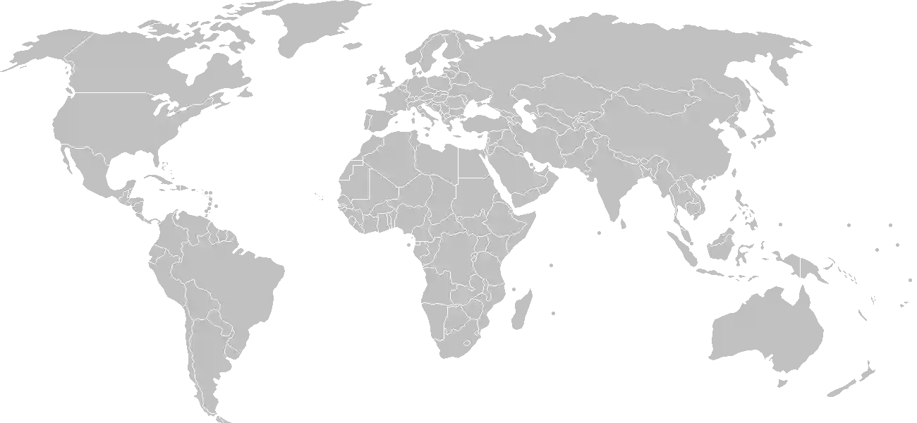
World Map Location
Geographic Location

Central Africa, bordering the Bight of Biafra, between Cameroon and Gabon

Map Reference
Africa

Area

Total Area
28,051 sq km
Land (100%)
Land: 28,051 sq km
Water: 0 sq km

Elevation

Highest Point
Pico Basile
Pico Basile 3,008 m
Lowest Point
Atlantic Ocean
Atlantic Ocean 0 m
Mean Elevation
577 m

Detailed Geography Information

Coastline

296 km

Geography - note

insular and continental regions widely separated; despite its name, no part of the equator passes through Equatorial Guinea -- the mainland part of the country is located just north of the equator

Irrigated land

NA

Land boundaries

Total boundary: 528 km
Cameroon 183 km
Gabon 345 km

Maritime claims

territorial sea: 12 nm exclusive economic zone: 200 nm

Natural hazards

violent windstorms; flash floods volcanism: Santa Isabel (3,007 m), which last erupted in 1923, is the country's only historically active volcano; Santa Isabel and two dormant volcanoes form Bioko Island in the Gulf of Guinea

Natural resources

petroleumnatural gastimbergoldbauxitediamondstantalumsand and gravelclay

Terrain

coastal plains rise to interior hills; islands are volcanic

Population & Growth

+3.10% Growth
1,853,559
Total inhabitants (2025 est.)
Male: 53.7% (994,672) Female: 46.3% (858,887)

Age Distribution

0-14 years
35.6%
~659,867
15-64 years
59.4%
~1,101,014
65 years
5.0%
~92,678
Note: 2024 est.

Demographic Longevity

Median Age
22.3 years
Male
22.7 yrs
Female
21.5 yrs
Life Expectancy
63.9 years
Male
61.6 yrs
Female
66.2 yrs

Vital Dynamics

Birth Rate
28.55
births per 1,000 people
Death Rate
8.81
deaths per 1,000 people
Net Migration
+11.29
migrants per 1,000 people
Fertility Rate
4.05
children born per woman

Detailed People & Society Information

Alcohol consumption per capita

6.11 liters of pure alcohol (2019 est.)

Dependency ratios

total dependency ratio: 67.4 (2025 est.) youth dependency ratio: 59 (2025 est.) elderly dependency ratio: 8.4 (2025 est.) potential support ratio: 11.9 (2025 est.)

Ethnic groups

Fang
78.1%
Bubi
9.4%
Ndowe
2.8%
Nanguedambo
2.7%
Bisio
0.9%
foreigner
5.3%
other
0.7%
unspecified
0.2%

Gross reproduction rate

1.99 (2025 est.)

Health expenditure

3.4%

3.4% of GDP (2021) 4.4% of national budget (2022 est.)

Infant mortality rate

total: 76.9 deaths/1,000 live births (2025 est.) male: 83.3 deaths/1,000 live births female: 71.3 deaths/1,000 live births

Languages

Spanish
67.6%
Fa d'Ambo spoken in Annobon
32.4%

Major urban areas - population

297,000 MALABO (capital) (2018)

Maternal mortality ratio

174 deaths/100,000 live births (2023 est.)

Nationality

noun: Equatorial Guinean(s) or Equatoguinean(s) adjective: Equatorial Guinean or Equatoguinean

Obesity - adult prevalence rate

8% (2016)

Physician density

0.15 physicians/1,000 population (2022)

Population distribution

the two large cities are Bata on the mainland and the capital Malabo on the island of Bioko; small communities are scattered throughout the mainland and the five inhabited islands, as shown in this population distribution map

Refugees and internally displaced persons

Total Displaced & Vulnerable Persons
5 individuals
Refugees
100.0%
5
5 (2024 est.)

Religions

Roman Catholic
88%
Protestant
5%
Muslim
2%
other (animist
5%

Sex ratio

at birth: 1.03 male(s)/female 0-14 years: 1.07 male(s)/female 15-64 years: 1.22 male(s)/female 65 years and over: 1.09 male(s)/female total population: 1.16 male(s)/female (2024 est.)

Climate & Issues

Climate Profile

tropical; always hot, humid

Key Environmental Issues
deforestation (agricultural expansion, fires, and grazing) desertification water pollution tap water non-potable wildlife preservation

Land Cover

Coverage Distribution
Forest (86%)
Arable: 1.9%
Crops: 1.7%
Pasture: 0.2%
Forest: 86.4%

Air & Carbon Emissions

Annual CO2 Output 2023 est.
5.471 million
Coal (0%) Oil (100%) Gas (0%)
PM2.5 Exposure 26.5 µg/m³
0 5 (WHO Limit) 15 25 35+
Methane Emissions
energy: 129.8 kt (2022-2024 est.)

Water Resources & Use

Renewable Water Resources 26 billion cubic meters (2022 est.)
Annual Water Withdrawal
municipal: 15.8 million cubic meters (2022 est.)
Municipal (80%) Ind (15%) Agri (5%)

Detailed Environmental Information

International environmental agreements

BiodiversityClimate ChangeClimate Change-Kyoto ProtocolClimate Change-Paris AgreementDesertificationEndangered SpeciesHazardous WastesLaw of the SeaMarine Dumping-London ConventionNuclear Test BanOzone Layer ProtectionShip PollutionWetlands

Urbanization

urban population: 74.4% of total population (2023) rate of urbanization: 3.62% annual rate of change (2020-25 est.)

Waste and recycling

municipal solid waste generated annually: 198,400 tons (2024 est.) percent of municipal solid waste recycled: 23.9% (2022 est.)

Capital & State Profile

Capital City
Malabo
3.75° N, 8.7833° E
Timezone UTC+1
Government Type
presidential republic
Independence 1968-10-12
National Holiday 10-12

Executive Branch

Chief of State
President OBIANG Nguema Mbasogo (since 3 August 1979)
Head of Government
Prime Minister Manuel Osa Nsue Nsua (since 17 August 2024)
Last Election 20 November 2022
Next Election 2029
Cabinet Council of Ministers appointed by the president and overseen by the prime minister

Legislative Branch

bicameral
Legislature Name Parliament (Parlamento)
Lower Chamber Chamber of Deputies (Cámara de los Diputados)
Seats 100 (all directly elected)
Term 5 years
% Women 31%
Parties Composition
Democratic Party of Equatorial Guinea (PDGE) and its allies 100
Upper Chamber Senate (Senado)
Seats 70 (55 directly elected; 15 appointed)
Term 5 years
% Women 25%
Parties Composition
Democratic Party of Equatorial Guinea (PDGE) and its allies 55

National Identity & Symbols

National Flag Description

three equal horizontal bands of green (top), white, and red, with a blue isosceles triangle based on the left side and the coat of arms centered in the white band; the coat of arms has six six-pointed yellow stars (representing the mainland and five offshore islands) above a gray shield with a silk-cotton tree; below is a scroll with the motto UNIDAD, PAZ, JUSTICIA (Unity, Peace, Justice)

Symbolic Meaning green stands for the jungle and natural resources, blue for the sea, white for peace, and red for the fight for independence
National Symbol silk cotton tree
National Colors green, white, red, blue
National Anthem Caminemos pisando la senda (Let Us Tread the Path)

Detailed Government Information

Administrative divisions

8 provinces (provincias, singular - provincia); Annobon, Bioko Norte, Bioko Sur, Centro Sur, Djibloho, Kie-Ntem, Litoral, Wele-Nzas

Citizenship

citizenship by birth: no citizenship by descent only: at least one parent must be a citizen of Equatorial Guinea dual citizenship recognized: no residency requirement for naturalization: 10 years

Constitution

history: previous 1968, 1973, 1982; approved by referendum 17 November 1991 amendment process: proposed by the president of the republic or supported by three fourths of the membership in either house of the National Assembly; passage requires three-fourths majority vote by both houses of the Assembly and approval in a referendum if requested by the president

Country name

conventional long form: Republic of Equatorial Guinea conventional short form: Equatorial Guinea local long form: Republica de Guinea Ecuatorial (Spanish)/ République de Guinée équatoriale (French) local short form: Guinea Ecuatorial (Spanish)/Guinée équatoriale (French) former: Spanish Guinea etymology: the country is named for the Guinea region of West Africa that lies along the Gulf of Guinea and stretches north to the Sahel; the "equatorial" refers to the fact that the country lies just north of the Equator

International law organization participation

accepts compulsory ICJ jurisdiction; accepts ICCt jurisdiction

International organization participation

Judicial branch

highest court(s): Supreme Court of Justice (consists of the President of the Supreme Court and nine judges organized into civil, criminal, commercial, labor, administrative, and customary sections); Constitutional Court (consists of the court president and 4 members) judge selection and term of office: Supreme Court judges appointed by the president for five-year terms; Constitutional Court members appointed by the president, 2 of whom are nominated by the Chamber of Deputies subordinate courts: Court of Guarantees; military courts; Courts of Appeal; first instance tribunals; district and county tribunals

Legal system

mixed system of civil and customary law

Political parties

Center Right Union or UCD Convergence Party for Social Democracy or CPDS Democratic Party for Equatorial Guinea or PDGE Liberal Democratic Convention or CLD Liberal Party or PL National Congress of Equatorial Guinea (CNGE) National Democratic Party (PNDGE) National Democratic Union or UDENA National Union for Democracy PUNDGE Popular Action of Equatorial Guinea or APGE Popular Union or UP Progressive Democratic Alliance or ADP Social and Popular Convergence Party or CSDP Social Democratic Coalition Party (PCSD) Social Democratic Party of Equatorial Guinea or PSDGE Social Democratic Union or UDS Socialist Party of Equatorial Guinea

Suffrage

18 years of age; universal

Economic Overview

growing CEMAC economy and new OPEC member; large oil and gas reserves; targeting economic diversification and poverty reduction; still recovering from CEMAC crisis; improving public financial management; persistent poverty; hard-hit by COVID-19

Size & Performance

Real GDP (PPP)
$29.248 billion
Latest available estimate (2024)
2023: $28.985 billion2022: $30.539 billion
Real GDP Growth
0.9% (2024 est.)
+0.9%
GDP Per Capita (PPP)
$15,500
2023: $15,7002022: $16,900

GDP Sector Breakdown

Agriculture: 3.1%Industry: 45.8%Services: 51.1%
Origin GDP %
Agriculture 3.1%
Industry 45.8%
Services 51.1%

Trade Balance

Trade Position
Trade Surplus
$1.25 billion
Total Exports
$4.489 billion (2024 est.)
Total Imports
$3.24 billion (2024 est.)
Exports (58%) Imports (42%)

Budget Balance

Budget Position
Budget Surplus
+$1.57 billion
Revenues
$3.62 billion (2022 est.)
Expenditures
$2.051 billion (2022 est.)
Revenues (64%) Expenditures (36%)

Export Profile

Top Export Partners

Note: 2023; top five export partners based on percentage share of exports

Major Export Commodities

crude petroleumnatural gasalcoholswoodscrap iron

Import Profile

Top Import Partners

20.0%
17.0%
10.0%
5.0%
5.0%
Note: 2023; top five import partners based on percentage share of imports

Major Import Commodities

shipspoultryplastic productsbeervalves

Labor & Employment

Total Labor Force 715,000 (2024 est.)
General Unemployment Rate 7.9%
Youth Unemployment (Ages 15-24) 14.7%

Income Inequality

Gini Coefficient (Family Income) 38.5
0 (Perfect Equality) Moderate Inequality 100 (Perfect Inequality)

Family Income / Consumption Share

Lowest 10%: 2.6% (2022 est.) Highest 10%: 29.1% (2022 est.)
Inequality Gap: Top 10% holds 11.2x the share of the bottom 10%.

Detailed Economic Data

Agricultural products

sweet potatoescassavaplantainsoil palm fruitroot vegetablesbananascoconutscoffeecocoa beanschicken

Exchange rates

Cooperation Financiere en Afrique Centrale francs (XAF) per US dollar - Exchange rates: 606.345 (2024 est.) 606.57 (2023 est.) 623.76 (2022 est.) 554.531 (2021 est.) 575.586 (2020 est.)

GDP - composition, by end use

Industrial production growth rate

0.8% (2024 est.) note: annual % change in industrial value added based on constant local currency

Industries

petroleumnatural gassawmilling

Inflation rate (consumer prices)

4.8% (2022 est.) -0.1% (2021 est.) 4.8% (2020 est.) note: annual % change based on consumer prices

Remittances

0% of GDP (2023 est.) 0% of GDP (2022 est.) 0% of GDP (2021 est.) note: personal transfers and compensation between resident and non-resident individuals/households/entities

Reserves of foreign exchange and gold

$1.538 billion (2023 est.) $1.458 billion (2022 est.) $44.271 million (2021 est.) note: holdings of gold (year-end prices)/foreign exchange/special drawing rights in current dollars

Taxes and other revenues

6.6% (of GDP) (2022 est.) note: central government tax revenue as a % of GDP

Grid Infrastructure

Electricity Access 67%
Urban: 89.8% Rural: 1.4%
Capacity 349,000 kW (2023 est.)
Consumption 1.402 billion kWh (2023 est.)
Grid Losses: 170.527 million kWh (2023 est.)

Generation Mix

Percentage Share of Production
fossil fuels 68.6%
hydroelectricity 31.4%

Fossil Fuels Production

Petroleum
Production 98,000 bbl/day (2023 est.)
Consumption 6,000 bbl/day (2023 est.)
Proven Reserves 1.1 billion barrels (2021 est.)
Natural Gas
Production 6.013 billion cubic meters (2023 est.)
Consumption 2.332 billion cubic meters (2023 est.)
Exports 3.63 billion cubic meters (2023 est.)
Proven Reserves 139.007 billion cubic meters (2021 est.)
Coal
Imports 8 metric tons (2023 est.)

Intensity & Nuclear

Energy Consumption Per Capita 54.509 million Btu/person (2023 est.)
No nuclear energy infrastructure or reactor operations reported in this country dossier.

Digital Access

.gq
Internet Usage 60%

Active internet users as a percentage of the total population.

Fixed Broadband

Penetration Rate 0 / 100
Total Subscriptions 2,000 (2022 est.)

Mobile Cellular

Penetration Rate 50 / 100
Total Subscriptions 893,000 (2022 est.)

Broadcast Media

the state maintains control of broadcast media; 1 state-owned TV station, 1 private TV station owned by the president's eldest son, 1 state-owned radio station, and 1 private radio station owned by the president's eldest son; satellite TV service is available; transmissions of multiple international broadcasters are generally accessible (2019)

Aviation

3C
Airports
7
As of 2025

Ports & Harbors

Ports Count 7
Hover for breakdown & key ports As of 2024

Merchant Marine

Commercial Fleet
53 ships
Hover for vessel types breakdown As of 2023

Military Expenditures

GDP Allocation 1%
1% of GDP (2024) 1.6% of GDP (2023 est.) 1.3% of GDP (2022 est.) 1.3% of GDP (2021 est.) 1.6% of GDP (2020 est.)

Active Duty Strengths

estimated 2,000 active Armed Forces, including Gendarmerie (2025)

Refers to active military personnel.

Service & Defense Details

Military and security forces

Equatorial Guinea Armed Forces (Fuerzas Armadas de Guinea Ecuatorial, FAGE): Army, Navy, Air Force, Gendarmerie (Guardia Civil) (2025) note: the National Police report to the Ministry of National Security, while the Gendarmerie reports to the Ministry of National Defense; police generally are responsible for maintaining law and order in the cities, while gendarmes are responsible for security outside cities and for special events

Military equipment inventories and acquisitions

the FAGE is armed with mostly older (typically Soviet-era) and secondhand weapons systems; in recent years, it has sought to modernize its naval inventory with purchases of vessels from several countries, including Bulgaria and Israel; China and Russia have also supplied some equipment to the FAGE (2025)

Military - note

the Armed Forces of Equatorial Guinea (FAGE) are responsible for defending the territory and sovereignty of the country; the FAGE also has some internal security duties, including fulfilling some police functions in border areas, sensitive sites, and high-traffic areas; maritime security, particularly protecting offshore oil installations and combating piracy and crime in the Gulf of Guinea, is a key priority (2025)

Military service age and obligation

18-25 for voluntary military service; selective compulsory military service for men; 24-month service obligation (2025)