🇱🇨

Saint Lucia

Central America and Caribbean • Countries
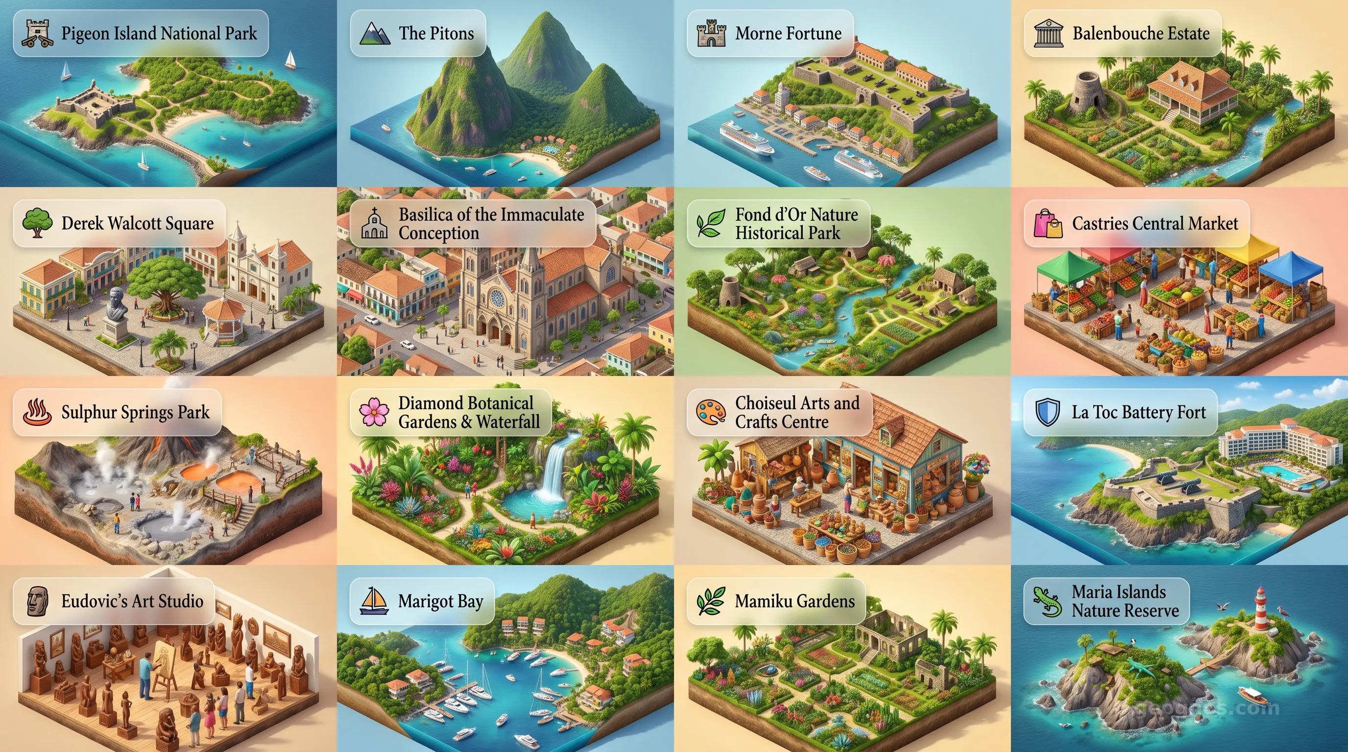
Saint Lucia - Panoramic Places of Interest Atlas including Pigeon Island National Park, The Pitons, Morne Fortune, Balenbouche Estate, Derek Walcott Square, Basilica of the Immaculate Conception, Fond d'Or Nature Historical Park, Castries Central Market, Sulphur Springs Park, Diamond Botanical Gardens & Waterfall, Choiseul Arts and Crafts Centre, La Toc Battery Fort, Eudovic's Art Studio, Marigot Bay, Mamiku Gardens, Maria Islands Nature Reserve

Top Sights & Landmarks

01

Pigeon Island National Park

Historic Island Fortress

02

The Pitons

Iconic Twin Volcanic Spires

03

Morne Fortune

Hill of Good Luck

04

Balenbouche Estate

Preserved 18th-Century Plantation

05

Derek Walcott Square

Castries' Cultural Heart

06

Basilica of the Immaculate Conception

Caribbean's Largest Cathedral

07

Fond d'Or Nature Historical Park

Ancient Amerindian Settlement

08

Castries Central Market

Vibrant Produce and Craft Hub

09

Sulphur Springs Park

Drive-In Volcano and Mud Baths

10

Diamond Botanical Gardens & Waterfall

Historic Mineral Baths and Flora

11

Choiseul Arts and Crafts Centre

Center of Indigenous Craftsmanship

12

La Toc Battery Fort

Hidden 19th-Century British Fort

13

Eudovic's Art Studio

Master Woodcarving Studio

14

Marigot Bay

Historic Hurricane Haven

15

Mamiku Gardens

Estate of the Brigand Wars

16

Maria Islands Nature Reserve

Protected Endemic Ecosystem

The Helen of the West: An Introduction to Saint Lucia

Emerging from the azure depths of the Caribbean Sea like a verdant cathedral of volcanic stone, Saint Lucia defies the typical postcard narrative of tropical islands. While many Caribbean locales are defined by the flatness of coral shelves or the monotonous sprawl of beaches, Saint Lucia possesses a verticality that feels ancient and cinematic. To stand before the Pitons, those twin volcanic spires piercing the clouds, is to understand why this island was once described as the "Helen of the West," fought over by empires for over a century, as if the beauty of the landscape itself were a prize of war.

Geography here is destiny. The island’s rugged topography, dominated by the Pitons and a dense, high-altitude rainforest, created natural fortresses that allowed indigenous Kalinago populations to hold their ground far longer than their counterparts elsewhere in the Caribbean. This ruggedness fostered a unique cultural resilience, blending African, French, and British influences into a tapestry that is distinctly Saint Lucian. To truly grasp how this geological theater shaped the lives of its inhabitants, you should explore the comprehensive history of Saint Lucia, which traces the journey from the volcanic cradle to modern nationhood through a detailed account of colonial transition, agricultural evolution, and the rise of the Creole spirit.

Volcanic Architecture and Cultural Roots

The soul of Saint Lucia is inextricably linked to its subterranean fires. The Qualibou volcanic region, home to the world’s only "drive-in" volcano, is not merely a geological curiosity but a foundational element of the island's persona. The rich, nutrient-dense volcanic soil allows for a lushness that borders on the prehistoric. Here, emerald-green hills tumble into secluded bays, creating pockets of biodiversity that have served as both a haven for local wildlife and a stage for human innovation.

History, however, is a layer cake of cultural influence. Unlike neighbors that transitioned smoothly between colonial powers, Saint Lucia famously swapped hands fourteen times between the French and the British. This historical turbulence, which you can test your knowledge of by playing our interactive Saint Lucia history puzzle to earn your scholar badges, left a linguistic and architectural inheritance that persists in the Kwéyòl language, the Catholic cathedrals of Castries, and the culinary mastery of saltfish and green fig.

The Living Archive of an Island Nation

Visual storytelling remains the most visceral way to bridge the gap between academic study and human experience. The evolution of Saint Lucia is a story told through fire and iron, colonial treaties, and eventually, the peaceful transition to democratic independence in 1979. To see this timeline come to life through a curated selection of archival illustrations and pedagogical narratives, we invite you to view the history cinematic showcase. This visual journey provides an evocative look at how shifting global powers left their footprints on these shores, providing an ideal resource for classrooms looking to visualize the complexities of Caribbean historiography.

Beyond the monuments of the past, the current landscape of the island serves as a siren song for the naturalist and the student of environmental science alike. From the lush rainforest reserves of the central highlands to the sheltered coastal coves that provide refuge to tropical marine life, the island acts as an outdoor laboratory. You can witness the majesty of these protected zones, the dramatic elevation changes of the Pitons, and the bustling life of the capital, Castries, by observing our POI cinematic showcase. This feature allows students and travelers to traverse the island from the comfort of their desks, gaining a profound appreciation for the diverse ecosystem that supports a growing economy and a vibrant, forward-thinking society.

A Crossroads of Caribbean Identity

Today, Saint Lucia functions as a nexus of culture where traditions are held with an intensity matched by few other islands. It is a place where Nobel Prize winners in literature, such as Derek Walcott and Sir Arthur Lewis, draw their creative inspiration directly from the soil and the sea. The island’s commitment to education and sustainable development suggests a future that balances the allure of global tourism with the sanctity of the natural world.

As you delve deeper into this page to explore the sections detailing the island’s modern governance, agricultural sectors, and telecommunications infrastructure, keep in mind the unique path that Saint Lucia traveled to arrive here. It is an island that spent centuries as a prize for kings and admirals, only to eventually bloom into a democratic lighthouse in the Caribbean. Whether you are analyzing the fiscal health of its service-oriented economy or studying the intricate social dynamics of its rural communities, you are engaging with a nation that has effectively leveraged its geographic uniqueness to build a sophisticated and distinct cultural identity that remains undeniably its own.
Location

Latitude
13.8833° N
Longitude
-60.9667° E
N S W E
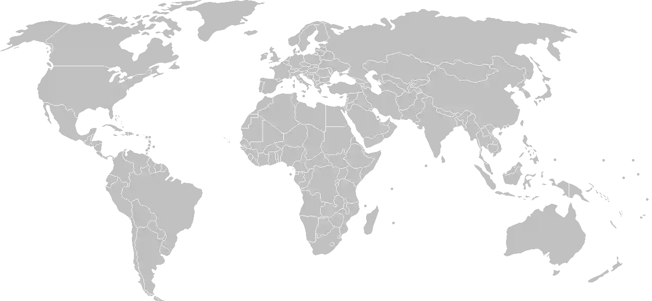
World Map Location
Geographic Location

Caribbean, island between the Caribbean Sea and North Atlantic Ocean, north of Trinidad and Tobago

Map Reference
Central America and the Caribbean

Area

Total Area
616 sq km
Land (98%)
Land: 606 sq km
Water: 10 sq km

Elevation

Highest Point
Mount Gimie
Mount Gimie 948 m
Lowest Point
Caribbean Sea
Caribbean Sea 0 m

Detailed Geography Information

Coastline

158 km

Geography - note

the twin Pitons (Gros Piton and Petit Piton), striking cone-shaped peaks south of Soufrière, are one of the scenic natural highlights of the Caribbean

Irrigated land

30 sq km (2012)

Land boundaries

total: 0 km

Maritime claims

territorial sea: 12 nm contiguous zone: 24 nm exclusive economic zone: 200 nm continental shelf: 200 nm or to the edge of the continental margin

Natural hazards

hurricanes volcanism: Mount Gimie (948 m), also known as Qualibou, is a caldera on the west of the island; the iconic twin pyramidal peaks of Gros Piton (771 m) and Petit Piton (743 m) are lava-dome remnants associated with the Soufrière volcano; there have been no historical magmatic eruptions, but a minor steam eruption in 1766 spread a thin layer of ash over a wide area; Saint Lucia is part of the volcanic-island arc of the Lesser Antilles that extends from Saba in the north to Grenada in the south

Natural resources

forestssandy beachesmineralsmineral springsgeothermal potential

Terrain

volcanic and mountainous with broad, fertile valleys

Population & Growth

+0.30% Growth
168,462
Total inhabitants (2025 est.)
Male: 48.5% (81,678) Female: 51.5% (86,784)

Age Distribution

0-14 years
17.9%
~30,155
15-64 years
66.7%
~112,364
65 years
15.4%
~25,943
Note: 2024 est.

Demographic Longevity

Median Age
40.4 years
Male
38.4 yrs
Female
40.9 yrs
Life Expectancy
79.4 years
Male
76.7 yrs
Female
82.3 yrs

Vital Dynamics

Birth Rate
11.17
births per 1,000 people
Death Rate
8.41
deaths per 1,000 people
Net Migration
-0.3
migrants per 1,000 people
Fertility Rate
1.71
children born per woman

Detailed People & Society Information

Alcohol consumption per capita

9.3 liters of pure alcohol (2019 est.)

Dependency ratios

total dependency ratio: 50.9 (2025 est.) youth dependency ratio: 26.6 (2025 est.) elderly dependency ratio: 24.3 (2025 est.) potential support ratio: 4.1 (2025 est.)

Education expenditure

3.8%

3.8% of GDP (2024 est.) 12.7% national budget (2025 est.)

Ethnic groups

Black/African descent
85.3%
mixed
10.9%
East Indian
2.2%
other
1.6%
unspecified
0.1%

Gross reproduction rate

0.83 (2025 est.)

Health expenditure

6.2%

6.2% of GDP (2021) 9% of national budget (2022 est.)

Hospital bed density

2 beds/1,000 population (2021 est.)

Infant mortality rate

total: 11.3 deaths/1,000 live births (2025 est.) male: 10.8 deaths/1,000 live births female: 12.2 deaths/1,000 live births

Languages

Major urban areas - population

22,000 CASTRIES (capital) (2018)

Maternal mortality ratio

44 deaths/100,000 live births (2023 est.)

Nationality

noun: Saint Lucian(s) adjective: Saint Lucian

Obesity - adult prevalence rate

19.7% (2016)

Physician density

4.23 physicians/1,000 population (2020)

Population distribution

most of the population is found on the periphery of the island, with a larger concentration in the north around the capital of Castries

Refugees and internally displaced persons

Total Displaced & Vulnerable Persons
5 individuals
Refugees
100.0%
5
5 (2024 est.)

Religions

Roman Catholic
61.5%
Protestant (includes Seventh Day Adventist
25.5%
Pentecostal
8.9%
Baptist
2.2%
Anglican
1.6%
Church of God
1.5%
other Protestant
0.9%
other Christian
3.4%
Rastafarian
1.9%
other
0.4%
none
5.9%
unspecified
1.4%

School life expectancy (primary to tertiary education)

total: 13 years (2023 est.) male: 12 years (2023 est.) female: 13 years (2023 est.)

Sex ratio

at birth: 1.06 male(s)/female 0-14 years: 1.06 male(s)/female 15-64 years: 0.94 male(s)/female 65 years and over: 0.83 male(s)/female total population: 0.94 male(s)/female (2024 est.)

Tobacco use

total: 13.1% (2025 est.) male: 24.1% (2025 est.) female: 2.6% (2025 est.)

Climate & Issues

Climate Profile

tropical, moderated by northeast trade winds; dry season January to April, rainy season May to August

Key Environmental Issues
deforestation soil erosion, particularly in the northern region

Land Cover

Coverage Distribution
Agri (16%)
Forest (54%)
Other (30%)
Arable: 4.4%
Crops: 11.3%
Pasture: 0.6%
Forest: 53.7%

Air & Carbon Emissions

Annual CO2 Output 2023 est.
605,000
Coal (0%) Oil (100%) Gas (0%)
PM2.5 Exposure 8.9 µg/m³
0 5 (WHO Limit) 15 25 35+

Water Resources & Use

Renewable Water Resources 300 million cubic meters (2022 est.)
Annual Water Withdrawal
municipal: 12.5 million cubic meters (2022 est.)
Municipal (29%) Ind (0%) Agri (71%)

Detailed Environmental Information

International environmental agreements

BiodiversityClimate ChangeClimate Change-Kyoto ProtocolClimate Change-Paris AgreementComprehensive Nuclear Test BanDesertificationEndangered SpeciesEnvironmental ModificationHazardous WastesLaw of the SeaMarine Dumping-London ConventionOzone Layer ProtectionShip PollutionWetlandsWhaling

Urbanization

urban population: 19.2% of total population (2023) rate of urbanization: 0.98% annual rate of change (2020-25 est.)

Waste and recycling

municipal solid waste generated annually: 77,600 tons (2024 est.) percent of municipal solid waste recycled: 13.3% (2022 est.)

Capital & State Profile

Capital City
Castries
14° N, -61° E
Timezone UTC-4
Government Type
parliamentary democracy under a constitutional monarchy; a Commonwealth realm
Independence 1979-02-22
National Holiday 02-22

Executive Branch

Chief of State
King CHARLES III (since 8 September 2022); represented by Acting Governor General Cyril Errol CHARLES
Head of Government
Prime Minister Philip J. PIERRE (since 28 July 2021)
Cabinet Cabinet appointed by the governor general on the advice of the prime minister

Legislative Branch

bicameral
Legislature Name Houses of Parliament
Lower Chamber House of Assembly
Seats 18 (all directly elected)
Term 5 years
% Women 10.5%
Parties Composition
Saint Lucia Labour Party (SLP) 13United Workers Party (UWP) 2Independents 2
Upper Chamber Senate
Seats 11 (all appointed)
Term 5 years
% Women 54.5%

National Identity & Symbols

National Flag Description

cerulean blue with a gold isosceles triangle below a black arrowhead; the upper edges of the arrowhead have a white border

Symbolic Meaning blue stands for the sky and sea, gold for sunshine and prosperity, and white and black for the ethnic composition of the island; the triangles represent Gros Piton and Petit Piton, the cone-shaped volcanic plugs that are a symbol of the island
National Symbol twin pitons (volcanic peaks), Saint Lucia parrot
National Colors cerulean blue, gold, black, white
National Anthem Sons and Daughters of St. Lucia

Detailed Government Information

Administrative divisions

10 districts; Anse-la-Raye, Canaries, Castries, Choiseul, Dennery, Gros-Islet, Laborie, Micoud, Soufrière, Vieux-Fort

Citizenship

citizenship by birth: yes citizenship by descent only: at least one parent must be a citizen of Saint Lucia dual citizenship recognized: yes residency requirement for naturalization: 8 years

Constitution

history: previous 1958, 1960 (pre-independence); latest presented 20 December 1978, effective 22 February 1979 amendment process: proposed by Parliament; passage requires at least two-thirds majority vote by the House of Assembly membership in the final reading and assent of the governor general; passage of amendments to various constitutional sections, such as those on fundamental rights and freedoms, government finances, the judiciary, and procedures for amending the constitution, require at least three-quarters majority vote by the House and assent of the governor general; passage of amendments approved by the House but rejected by the Senate require a majority of votes cast in a referendum

Country name

conventional long form: none conventional short form: Saint Lucia etymology: believed to be named after Saint LUCY (Sainte ALOUSIE) of Syracuse by French sailors who were shipwrecked on the island on 13 December 1502, the saint's feast day note: pronounced saynt-LOO-shuh

International law organization participation

has not submitted an ICJ jurisdiction declaration; accepts ICCt jurisdiction

International organization participation

Judicial branch

highest court(s): the Eastern Caribbean Supreme Court (ECSC) is the superior court of the Organization of Eastern Caribbean States; the ECSC is headquartered on St. Lucia and consists of the Court of Appeal -- headed by the chief justice and 4 judges -- and the High Court with 18 judges; the Court of Appeal travels to member states on a schedule to hear appeals from the High Court and subordinate courts; member of the Caribbean Court of Justice judge selection and term of office: chief justice of Eastern Caribbean Supreme Court appointed by the British monarch; other justices and judges appointed by the Judicial and Legal Services Commission, an independent body of judicial officials; Court of Appeal justices appointed for life with mandatory retirement at age 65; High Court judges appointed for life with mandatory retirement at age 62 subordinate courts: magistrate's court

Legal system

English common law

National heritage

total World Heritage Sites: 1 (natural) selected World Heritage Site locales: Pitons Management Area

Political parties

Saint Lucia Labor Party or SLP United Workers Party or UWP

Suffrage

18 years of age; universal

Economic Overview

upper middle-income, tourism-based Caribbean island economy; environmentally fragile; energy import-dependent; major banana producer; well-educated labor force; key infrastructure, IT, and communications investments

Size & Performance

Real GDP (PPP)
$4.359 billion
Latest available estimate (2024)
2023: $4.196 billion2022: $4.105 billion
Real GDP Growth
3.9% (2024 est.)
+3.9%
GDP Per Capita (PPP)
$24,300
2023: $23,4002022: $23,000

GDP Sector Breakdown

Agriculture: 1.1%Industry: 9.8%Services: 75.9%
Origin GDP %
Agriculture 1.1%
Industry 9.8%
Services 75.9%

Trade Balance

Trade Position
Trade Surplus
$154.00 million
Total Exports
$1.6 billion (2024 est.)
Total Imports
$1.446 billion (2024 est.)
Exports (53%) Imports (47%)

Budget Balance

Budget Position
Budget Surplus
+$62.81 million
Revenues
$414.77 million (2017 est.)
Expenditures
$351.956 million (2017 est.)
Revenues (54%) Expenditures (46%)

Export Profile

Top Export Partners

Note: 2023; top five export partners based on percentage share of exports

Major Export Commodities

refined petroleumgravel and crushed stonebeerliquorpaper containers

Import Profile

Top Import Partners

59.0%
5.0%
3.0%
Note: 2023; top five import partners based on percentage share of imports

Major Import Commodities

refined petroleumcrude petroleumcarspoultryplastic products

Labor & Employment

Total Labor Force 102,400 (2024 est.)
General Unemployment Rate 11%
Youth Unemployment (Ages 15-24) 29.0%
Population Below Poverty Line 25% (2015 est.)

Income Inequality

Gini Coefficient (Family Income) 51.2
0 (Perfect Equality) High Inequality 100 (Perfect Inequality)

Family Income / Consumption Share

Lowest 10%: 2.1% (2015 est.) Highest 10%: 34.1% (2015 est.)
Inequality Gap: Top 10% holds 16.2x the share of the bottom 10%.

Detailed Economic Data

Agricultural products

coconutsbananastropical fruitsfruitsroot vegetablesplantainsvegetablescassavachickenmilk

Current account balance

-$64.121 million (2024 est.) -$38.069 million (2023 est.) -$83.442 million (2022 est.) note: balance of payments - net trade and primary/secondary income in current dollars

Debt - external

$901.317 million (2023 est.) note: present value of external debt in current US dollars

Exchange rates

East Caribbean dollars (XCD) per US dollar - Exchange rates: 2.7 (2024 est.) 2.7 (2023 est.) 2.7 (2022 est.) 2.7 (2021 est.) 2.7 (2020 est.)

GDP - composition, by end use

Industrial production growth rate

5.6% (2024 est.) note: annual % change in industrial value added based on constant local currency

Industries

tourismclothingassembly of electronic componentsbeveragescorrugated cardboard boxeslime processingcoconut processing

Inflation rate (consumer prices)

-0.1% (2024 est.) 4.1% (2023 est.) 6.4% (2022 est.) note: annual % change based on consumer prices

Remittances

2.5% of GDP (2024 est.) 2.6% of GDP (2023 est.) 2.6% of GDP (2022 est.) note: personal transfers and compensation between resident and non-resident individuals/households/entities

Reserves of foreign exchange and gold

$406.064 million (2024 est.) $424.324 million (2023 est.) $389.083 million (2022 est.) note: holdings of gold (year-end prices)/foreign exchange/special drawing rights in current dollars

Taxes and other revenues

18.2% (of GDP) (2017 est.) note: central government tax revenue as a % of GDP

Grid Infrastructure

Electricity Access 100%
Capacity 93,000 kW (2023 est.)
Consumption 365.178 million kWh (2023 est.)
Grid Losses: 31.038 million kWh (2023 est.)

Generation Mix

Percentage Share of Production
fossil fuels 98%
solar 2%

Fossil Fuels Production

Petroleum
Consumption 4,000 bbl/day (2023 est.)

Intensity & Nuclear

Energy Consumption Per Capita 47.522 million Btu/person (2023 est.)
No nuclear energy infrastructure or reactor operations reported in this country dossier.

Digital Access

.lc
Internet Usage 74%

Active internet users as a percentage of the total population.

Fixed Broadband

Penetration Rate 14 / 100
Total Subscriptions 24,000 (2022 est.)

Mobile Cellular

Penetration Rate 99 / 100
Total Subscriptions 176,000 (2022 est.)

Broadcast Media

3 privately owned TV stations; 1 public TV station on a cable network; multi-channel cable TV service available; mix of state-owned and privately owned radio broadcasters with about 25 stations, including repeater transmission stations (2019)

Aviation

J6
Airports
2
As of 2025

Ports & Harbors

Ports Count 3
Hover for breakdown & key ports As of 2024

Service & Defense Details

Military and security forces

no regular military forces; Ministry of Home Affairs, Justice, and National Security: Royal Saint Lucia Police Force (RSLPF) (2025)

Military - note

Saint Lucia has been a member of the Caribbean Regional Security System (RSS) since its creation in 1982; RSS signatories (Antigua and Barbuda, Barbados, Dominica, Grenada, Guyana, Saint Kitts, and Saint Vincent and the Grenadines) agreed to prepare contingency plans and assist one another, on request, in national emergencies, prevention of smuggling, search and rescue, immigration control, fishery protection, customs and excise control, maritime policing duties, protection of off-shore installations, pollution control, national and other disasters, and threats to national security (2025)