🇸🇹

Sao Tome and Principe

Africa Countries
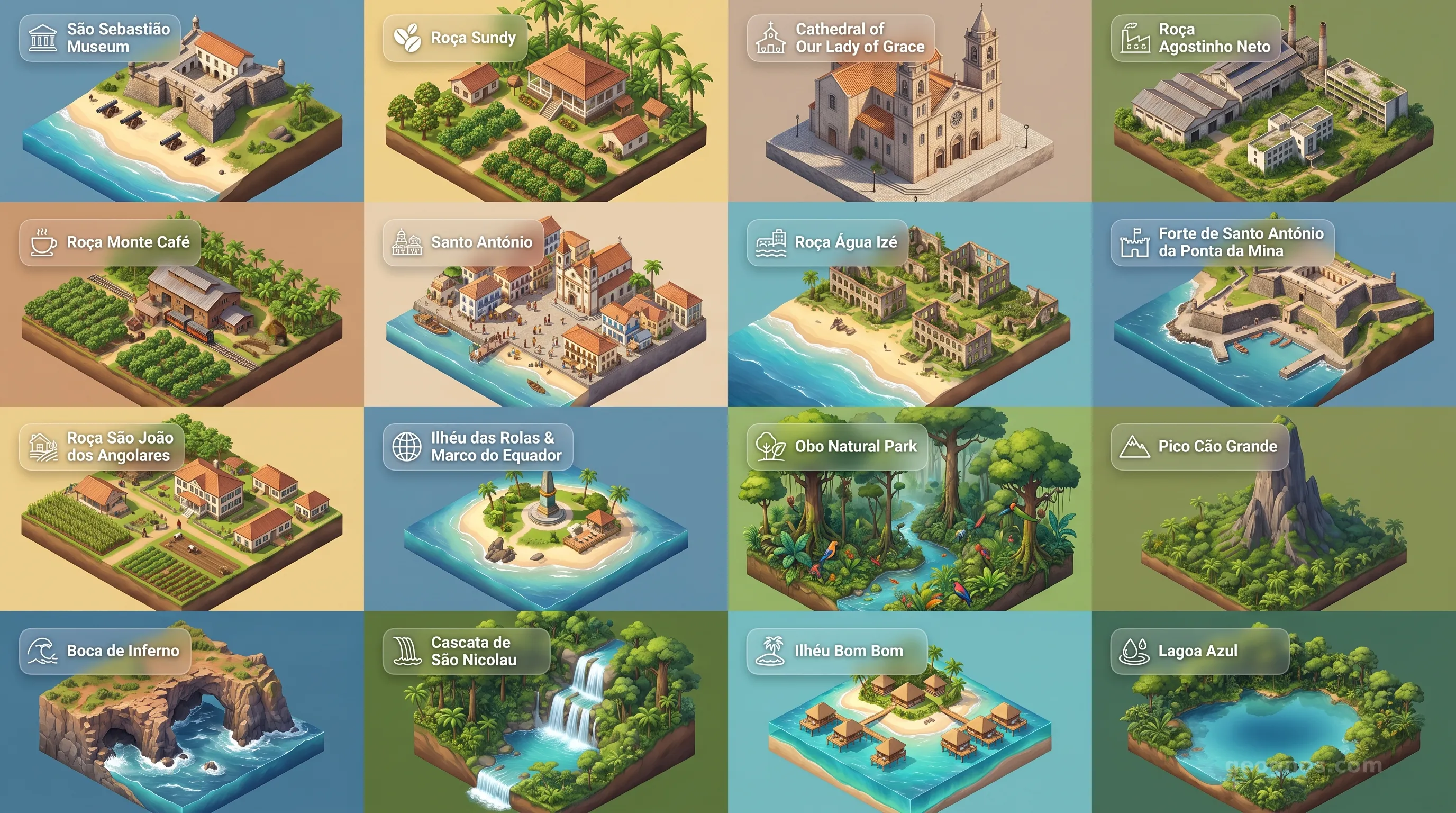
Sao Tome and Principe - Panoramic Places of Interest Atlas including São Sebastião Museum, Roça Sundy, Cathedral of Our Lady of Grace, Roça Agostinho Neto, Roça Monte Café, Santo António, Roça Água Izé, Forte de Santo António da Ponta da Mina, Roça São João dos Angolares, Ilhéu das Rolas & Marco do Equador, Obo Natural Park, Pico Cão Grande, Boca de Inferno, Cascata de São Nicolau, Ilhéu Bom Bom, Lagoa Azul

Top Sights & Landmarks

01

São Sebastião Museum

National Museum in a 16th-Century Fortress

02

Roça Sundy

Historic Plantation and Birthplace of Relativity Proof

03

Cathedral of Our Lady of Grace

16th-Century Colonial Cathedral

04

Roça Agostinho Neto

Grand Colonial Cocoa Plantation

05

Roça Monte Café

Oldest Mountain Coffee Plantation

06

Santo António

The Smallest City in the World

07

Roça Água Izé

Haunting Ruins of a Cocoa Empire

08

Forte de Santo António da Ponta da Mina

17th-Century Coastal Fortress Ruins

09

Roça São João dos Angolares

Cultural Hub and Culinary Landmark

10

Ilhéu das Rolas & Marco do Equador

The Center of the World Monument

11

Obo Natural Park

Pristine Volcanic Biosphere Reserve

12

Pico Cão Grande

Towering Volcanic Needle Peak

13

Boca de Inferno

The Roaring Mouth of Hell Blowhole

14

Cascata de São Nicolau

Lush Jungle Waterfall

15

Ilhéu Bom Bom

Eco-Tourism Pioneer Islet

16

Lagoa Azul

The Baobab-Fringed Blue Lagoon

The Equatorial Garden: Africa’s Hidden Archipelago

Rising like emerald shards from the deep, cobalt silence of the Gulf of Guinea, the islands of São Tomé and Príncipe occupy a space in the world that feels both forgotten by time and protected by the vast expanse of the Atlantic. This is a land where the mist never truly leaves the canopy of the rainforest, where the air is heavy with the scent of fermenting cacao, and where the jagged teeth of volcanic basalt break through the froth of the equatorial surf. To understand this nation is to look past the map. One must feel the rhythmic pulse of its tides and the complex, layered stories etched into its verdant, steep-sided slopes.

Often referred to as the Galápagos of Africa due to their astonishing levels of biodiversity and unique flora and fauna, these two islands—along with a scattering of smaller islets—represent a geographical anomaly. They were not once attached to the continent of Africa. Instead, they were birthed from the sea, thrust upward by deep-crustal volcanic activity. This isolation has allowed a distinct natural identity to flourish, resulting in a sanctuary for life that exists nowhere else on Earth. But the soul of the nation is not found in the biology alone. It is found in the way humanity has attempted to tame, trade, and eventually coexist with a landscape that remains inherently wild.

The Echoes of Industry and Resilience

The story of human arrival on these shores is as turbulent as the surrounding sea. Unlike the mainland, these islands were uninhabited until the Portuguese navigators sighted them in the late 15th century. This blank slate allowed for a singular, though often difficult, history to unfold. The islands eventually became the world's leading producer of cocoa in the early 20th century, a period during which they were famously known as the "Chocolate Islands." Yet, beneath the veneer of agricultural prosperity lies a deeper, more poignant human legacy.

To truly grasp how these islands transitioned from uninhabited volcanic peaks to a cultural mosaic, one should explore the comprehensive history of São Tomé and Príncipe. This narrative tracks the complex development of the archipelago, detailing the labor history of the plantation era and the eventual emergence of an independent, democratic spirit. The journey from colonization to sovereignty is a central pillar of the national identity, and we invite students and historians alike to test their knowledge with our interactive history puzzle, which challenges users to organize these transformative milestones in the correct sequence to earn virtual recognition.

A Landscape Sculpted by Volcanics

The geography of the nation is dominated by the Pico de São Tomé, a dormant volcanic peak that pierces the cloud layer at over two thousand meters. Its rugged, inaccessible slopes serve as the spine of the nation. These mountains dictate the rainfall patterns, turning the southern windward slopes into lush, dripping primary forests, while the northern rain-shadow zones dry into savannahs. For the educator or the traveler, the landscape serves as a living laboratory.

If you wish to visualize these geological marvels and the remnants of the grand colonial plantation houses, known locally as roças, you can engage with our history cinematic showcase. This feature brings the primary events of the past to life through vivid illustrations and narrative synopses. Likewise, for those captivated by the visual grandeur of the present-day archipelago, our point of interest cinematic showcase offers a breathtaking tour through the misty peaks of the Obo National Park, the dramatic basalt pillars of the coast, and the vibrant, pastel-hued life of the capital city.

Cultural Crossings in the Middle of Nowhere

The people of São Tomé and Príncipe are the architects of a unique synthesis. The fusion of Portuguese linguistic heritage with deep-rooted African customs and the remnants of forced migrations from throughout the continent has created a society that feels intensely communal. You hear it in the Tchiloli, a traditional dance-drama that blends medieval European storytelling with African rhythmic performance, and you see it in the culinary reliance on the ocean and the fertile soil, yielding plates filled with mountain fruit and freshly caught Atlantic fish.

The modern nation-state, having moved past the intense monoculture of the colonial era, now focuses on sustainable development and the preservation of its ecological wealth. The government and the local populations are increasingly stewards of the "Blue Economy," recognizing that their greatest asset is the preservation of the unique equilibrium that allows such biodiversity to thrive. The archipelago is not just a destination; it is an enduring example of how small nations can maintain global significance through the preservation of their heritage and their environment.

Finding the Soul of the Islands

Visitors who land on the airstrip at São Tomé are immediately struck by the silence, followed by the symphony of the tropics. The birds, many of them endemic, provide a soundtrack that reminds the traveler that they are guests in a landscape that has spent millions of years refining itself. The nation is a testament to the fact that isolation can breed innovation and that beauty often persists in the most rugged of environments. Whether you are studying the colonial architecture of the old Roças, tracking the migration patterns of sea turtles on the sandy beaches of Príncipe, or examining the geological forces that birthed these mountains, São Tomé and Príncipe offers a profound masterclass in the intersection of nature and history.

As we journey through this GeoGnos exploration of the islands, we hope you view this nation not merely as a small dot on the Atlantic map, but as a robust, resilient, and beautiful testament to the capacity for life—and human culture—to bloom in even the most remote corners of the world. Each corner of the island invites curiosity, and each chapter of its story invites deep, academic reflection. Welcome to the heart of the Gulf of Guinea.
Location

Latitude
1° N
Longitude
7° E
N S W E
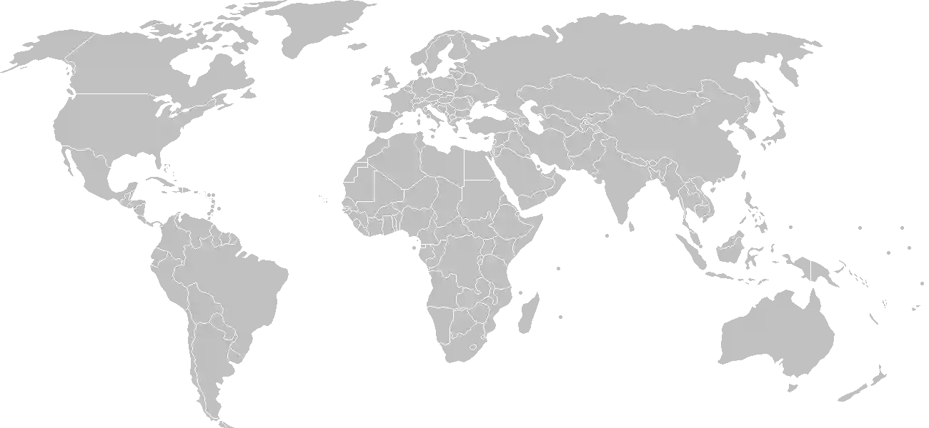
World Map Location
Geographic Location

Central Africa, islands in the Gulf of Guinea, just north of the Equator, west of Gabon

Map Reference
Africa

Area

Total Area
964 sq km
Land (100%)
Land: 964 sq km
Water: 0 sq km

Elevation

Highest Point
Pico de Sao Tome
Pico de Sao Tome 2,024 m
Lowest Point
Atlantic Ocean
Atlantic Ocean 0 m

Detailed Geography Information

Coastline

209 km

Geography - note

the second-smallest African country (after the Seychelles); the two main islands form part of a chain of extinct volcanoes, and both are mountainous

Irrigated land

100 sq km (2012)

Land boundaries

total: 0 km

Maritime claims

territorial sea: 12 nm exclusive economic zone: 200 nm note: measured from claimed archipelagic baselines

Natural hazards

flooding

Natural resources

fishhydropower

Terrain

volcanic, mountainous

Population & Growth

+1.40% Growth
226,722
Total inhabitants (2025 est.)
Male: 49.9% (113,129) Female: 50.1% (113,593)

Age Distribution

0-14 years
36.4%
~82,527
15-64 years
60.3%
~136,713
65 years
3.2%
~7,255
Note: 2024 est.

Demographic Longevity

Median Age
21.2 years
Male
20.4 yrs
Female
21.2 yrs
Life Expectancy
67.7 years
Male
66 yrs
Female
69.4 yrs

Vital Dynamics

Birth Rate
25.87
births per 1,000 people
Death Rate
5.84
deaths per 1,000 people
Net Migration
-6.15
migrants per 1,000 people
Fertility Rate
3.18
children born per woman

Detailed People & Society Information

Alcohol consumption per capita

4.23 liters of pure alcohol (2019 est.)

Children under the age of 5 years underweight

5.4% (2019 est.)

Currently married women (ages 15-49)

53.1% (2019 est.)

Dependency ratios

total dependency ratio: 63.9 (2025 est.) youth dependency ratio: 58.4 (2025 est.) elderly dependency ratio: 5.5 (2025 est.) potential support ratio: 18.2 (2025 est.)

Education expenditure

5%

5% of GDP (2023 est.) 18.1% national budget (2024 est.)

Ethnic groups

Gross reproduction rate

1.57 (2025 est.)

Health expenditure

7.8%

7.8% of GDP (2021) 14.9% of national budget (2022 est.)

Hospital bed density

2.9 beds/1,000 population (2019 est.)

Infant mortality rate

total: 41.7 deaths/1,000 live births (2025 est.) male: 46.1 deaths/1,000 live births female: 39 deaths/1,000 live births

Languages

Portuguese
98.4%
Forro
36.2%
Cabo Verdian
8.5%
French
6.8%
Angolar
6.6%
English
4.9%
Lunguie
1%
other ; other Portuguese-based Creoles are also spoken
2.4%

Literacy

total population: 87.4% (2019 est.) male: 92.5% (2019 est.) female: 82.8% (2019 est.)

Major urban areas - population

80,000 SAO TOME (capital) (2018)

Maternal mortality ratio

75 deaths/100,000 live births (2023 est.)

Mother's mean age at first birth

19.4 years (2008/09 est.) note: data represents median age at first birth among women 25-29

Nationality

noun: Sao Tomean(s) adjective: Sao Tomean

Obesity - adult prevalence rate

12.4% (2016)

Physician density

0.46 physicians/1,000 population (2022)

Population distribution

Sao Tome, the capital city, has roughly a quarter of the nation's population; Santo Antonio is the largest town on Principe; the northern areas of both islands have the highest population densities, as shown in this population distribution map

Religions

Catholic
55.7%
Adventist
4.1%
Assembly of God
3.4%
New Apostolic
2.9%
Mana
2.3%
Universal Kingdom of God
2%
Jehovah's Witness
1.2%
other
6.2%
none
21.2%
unspecified
1%

School life expectancy (primary to tertiary education)

total: 13 years (2021 est.) male: 13 years (2021 est.) female: 13 years (2021 est.)

Sex ratio

at birth: 1.03 male(s)/female 0-14 years: 1.03 male(s)/female 15-64 years: 0.99 male(s)/female 65 years and over: 0.75 male(s)/female total population: 1 male(s)/female (2024 est.)

Tobacco use

total: 7.3% (2025 est.) male: 13.1% (2025 est.) female: 1.7% (2025 est.)

Climate & Issues

Climate Profile

tropical; hot, humid; one rainy season (October to May)

Key Environmental Issues
deforestation and illegal logging soil erosion and exhaustion inadequate sewage treatment in cities biodiversity

Land Cover

Coverage Distribution
Agri (45%)
Forest (57%)
Arable: 4.2%
Crops: 39.6%
Pasture: 1.0%
Forest: 57.5%

Air & Carbon Emissions

Annual CO2 Output 2023 est.
146,000
Coal (0%) Oil (100%) Gas (0%)
PM2.5 Exposure 29 µg/m³
0 5 (WHO Limit) 15 25 35+

Water Resources & Use

Renewable Water Resources 2.18 billion cubic meters (2022)
Annual Water Withdrawal
municipal: 14.7 million cubic meters (2022 est.)
Municipal (36%) Ind (1%) Agri (63%)

Detailed Environmental Information

International environmental agreements

BiodiversityClimate ChangeClimate Change-Kyoto ProtocolClimate Change-Paris AgreementDesertificationEndangered SpeciesEnvironmental ModificationHazardous WastesLaw of the SeaOzone Layer ProtectionShip PollutionWetlandsWhaling

Urbanization

urban population: 76.4% of total population (2023) rate of urbanization: 2.96% annual rate of change (2020-25 est.)

Waste and recycling

municipal solid waste generated annually: 25,600 tons (2024 est.) percent of municipal solid waste recycled: 16.9% (2022 est.)

Capital & State Profile

Capital City
Sao Tome
0.3333° N, 6.7333° E
Timezone UTC 0
Government Type
semi-presidential republic
Independence 1975-07-12
National Holiday 07-12

Executive Branch

Chief of State
President Carlos Manuel VILA NOVA (since 2 October 2021)
Head of Government
Prime Minister Américo d'Oliveira DOS RAMOS (since 12 January 2025)
Last Election 18 July 2021, with a runoff on 5 September 2021
Next Election 2026
Cabinet Council of Ministers proposed by the prime minister, appointed by the president

Legislative Branch

unicameral
Legislature Name National Assembly (Assembleia Nacional)
Seats & Term
55 (all directly elected) seats / 4 years
Women in Chamber
14.5% Representation
Electoral System proportional representation
Parties Composition
Independent Democratic Alliance (ADI) 30Sao Tome and Principe Liberation Movement/Social Democratic Party (MLSTP - PSD) 18Movement of Independent Citizens - Socialist Party (MCI - PS) - National Unity Party (PUN) 5Other 2

National Identity & Symbols

National Flag Description

three horizontal bands of green (top), yellow (double-width), and green with two five-pointed black stars in the center of the yellow band and a red isosceles triangle based on the left side

Symbolic Meaning green stands for the country's rich vegetation, red for the struggle for independence, and yellow for cocoa, one of the country's main agricultural products; the two stars symbolize the main islands
National Symbol palm tree
National Colors green, yellow, red, black
National Anthem Independencia total (Total Independence)

Detailed Government Information

Administrative divisions

6 districts (distritos, singular - distrito), 1 autonomous region* (regiao autonoma); Agua Grande, Cantagalo, Caue, Lemba, Lobata, Me-Zochi, Principe*

Citizenship

citizenship by birth: no citizenship by descent only: at least one parent must be a citizen of Sao Tome and Principe dual citizenship recognized: no residency requirement for naturalization: 5 years

Constitution

history: approved 5 November 1975 amendment process: proposed by the National Assembly; passage requires two-thirds majority vote by the Assembly; the Assembly can propose to the president of the republic that an amendment be submitted to a referendum

Country name

conventional long form: Democratic Republic of Sao Tome and Principe conventional short form: Sao Tome and Principe local long form: Republica Democratica de Sao Tome e Principe local short form: Sao Tome e Principe etymology: Sao Tome was named after Saint THOMAS the Apostle by the Portuguese who discovered the island on 21 December 1470 (or 1471), the saint's feast day; Principe is a shortening of the original Portuguese name of "Ilha do Principe" (Isle of the Prince), referring to Prince ALPHONSO of Portugal

International law organization participation

has not submitted an ICJ jurisdiction declaration; non-party state to the ICCt

International organization participation

Judicial branch

highest court(s): Supreme Court or Supremo Tribunal Justica (consists of 5 judges); Constitutional Court or Tribunal Constitucional (consists of 5 judges, 3 of whom are from the Supreme Court) judge selection and term of office: Supreme Court judges appointed by the National Assembly; judge tenure NA; Constitutional Court judges nominated by the president and elected by the National Assembly for 5-year terms subordinate courts: Court of First Instance; Audit Court

Legal system

mixed system of civil law based on the Portuguese model and customary law

Political parties

BASTA Movement Independent Democratic Action or ADI Movement for the Liberation of Sao Tome and Principe-Social Democratic Party or MLSTP-PSD Movement of Independent Citizens of São Tomé and Príncipe - Socialist Party or MCI-PS National Unity Party or PUN

Suffrage

18 years of age; universal

Economic Overview

lower middle-income Central African island economy; falling cocoa production due to drought and mismanagement; joint oil venture with Nigeria; government owns 90% of land; high debt, partly from fuel subsidies; tourism gutted by COVID-19

Size & Performance

Real GDP (PPP)
$1.291 billion
Latest available estimate (2024)
2023: $1.279 billion2022: $1.275 billion
Real GDP Growth
0.9% (2024 est.)
+0.9%
GDP Per Capita (PPP)
$5,500
2023: $5,5002022: $5,600

GDP Sector Breakdown

Agriculture: 12.8%Industry: 2.9%Services: 76.6%
Origin GDP %
Agriculture 12.8%
Industry 2.9%
Services 76.6%

Trade Balance

Trade Position
Trade Deficit
$122.34 million
Total Exports
$96.977 million (2022 est.)
Total Imports
$219.322 million (2022 est.)
Exports (31%) Imports (69%)

Budget Balance

Budget Position
Budget Deficit
-$37.18 million
Revenues
$128.767 million (2022 est.)
Expenditures
$165.95 million (2022 est.)
Revenues (44%) Expenditures (56%)

Export Profile

Top Export Partners

Note: 2023; top five export partners based on percentage share of exports

Major Export Commodities

crude petroleumcocoa beansvehicle parts/accessoriespalm oilaircraft parts

Import Profile

Top Import Partners

13.0%
11.0%
8.0%
6.0%
Note: 2023; top five import partners based on percentage share of imports

Major Import Commodities

shipsrefined petroleumriceelectric generating setscars

Labor & Employment

Total Labor Force 34,500 (2024 est.)
General Unemployment Rate 9.2%
Youth Unemployment (Ages 15-24) 8.6%
Population Below Poverty Line 55.5% (2017 est.)

Income Inequality

Gini Coefficient (Family Income) 40.7
0 (Perfect Equality) High Inequality 100 (Perfect Inequality)

Family Income / Consumption Share

Lowest 10%: 2.6% (2017 est.) Highest 10%: 32.8% (2017 est.)
Inequality Gap: Top 10% holds 12.6x the share of the bottom 10%.

Detailed Economic Data

Agricultural products

plantainsoil palm fruittarobananasfruitscocoa beansyamscoconutscassavavegetables

Current account balance

-$79.437 million (2022 est.) -$95.248 million (2021 est.) -$59.595 million (2020 est.) note: balance of payments - net trade and primary/secondary income in current dollars

Debt - external

$327.248 million (2023 est.) note: present value of external debt in current US dollars

Exchange rates

dobras (STD) per US dollar - Exchange rates: 22.658 (2023 est.) 23.29 (2022 est.) 20.71 (2021 est.) 21.507 (2020 est.) 21.885 (2019 est.)

GDP - composition, by end use

Industrial production growth rate

3.2% (2024 est.) note: annual % change in industrial value added based on constant local currency

Industries

light constructiontextilessoapbeerfish processingtimber

Inflation rate (consumer prices)

14.4% (2024 est.) 21.3% (2023 est.) 18% (2022 est.) note: annual % change based on consumer prices

Remittances

1.5% of GDP (2023 est.) 1.9% of GDP (2022 est.) 2% of GDP (2021 est.) note: personal transfers and compensation between resident and non-resident individuals/households/entities

Reserves of foreign exchange and gold

$46.247 million (2023 est.) $64.476 million (2022 est.) $75.017 million (2021 est.) note: holdings of gold (year-end prices)/foreign exchange/special drawing rights in current dollars

Grid Infrastructure

Electricity Access 78%
Urban: 80% Rural: 73.7%
Capacity 29,000 kW (2023 est.)
Consumption 47.05 million kWh (2023 est.)
Grid Losses: 40.95 million kWh (2023 est.)

Generation Mix

Percentage Share of Production
fossil fuels 93.2%
hydroelectricity 6.8%

Fossil Fuels Production

Petroleum
Consumption 1,000 bbl/day (2023 est.)

Intensity & Nuclear

Energy Consumption Per Capita 8.875 million Btu/person (2023 est.)
No nuclear energy infrastructure or reactor operations reported in this country dossier.

Digital Access

.st
Internet Usage 62%

Active internet users as a percentage of the total population.

Fixed Broadband

Penetration Rate 3 / 100
Total Subscriptions 6,000 (2023 est.)

Mobile Cellular

Penetration Rate 62 / 100
Total Subscriptions 147,000 (2024 est.)

Broadcast Media

1 state-owned TV station; 2 state-owned radio stations; 7 independent local radio stations; transmissions of multiple international broadcasters are available

Aviation

S9
Airports
2
As of 2025

Ports & Harbors

Ports Count 2
Hover for breakdown & key ports As of 2024

Merchant Marine

Commercial Fleet
25 ships
Hover for vessel types breakdown As of 2023

Active Duty Strengths

approximately 500 active Armed Forces (2023)

Refers to active military personnel.

Service & Defense Details

Military and security forces

Armed Forces of Sao Tome and Principe (Forcas Armadas de Sao Tome e Principe, FASTP): Army, Coast Guard of Sao Tome e Principe (Guarda Costeira de Sao Tome e Principe, GCSTP), Presidential Guard, National Guard (2025) note: the Army and Coast Guard are responsible for external security while the public security police and judicial police maintain internal security; both the public security police and the military report to the Ministry of Defense and Internal Affairs; the judicial police report to the Ministry of Justice, Public Administration, and Human Rights

Military equipment inventories and acquisitions

the FASTP is lightly armed and has a small inventory of mostly older weapons and equipment (2023)

Military - note

the FASTP is one of the smallest militaries in Africa and consists of only a few companies of ground troops and some small patrol boats (2024)

Military service age and obligation

limited information; 18 is the minimum age for compulsory military service (reportedly not enforced) and 17 years of age (with parental permission) for voluntary service (2024)