🇳🇪

Niger

Africa • Countries
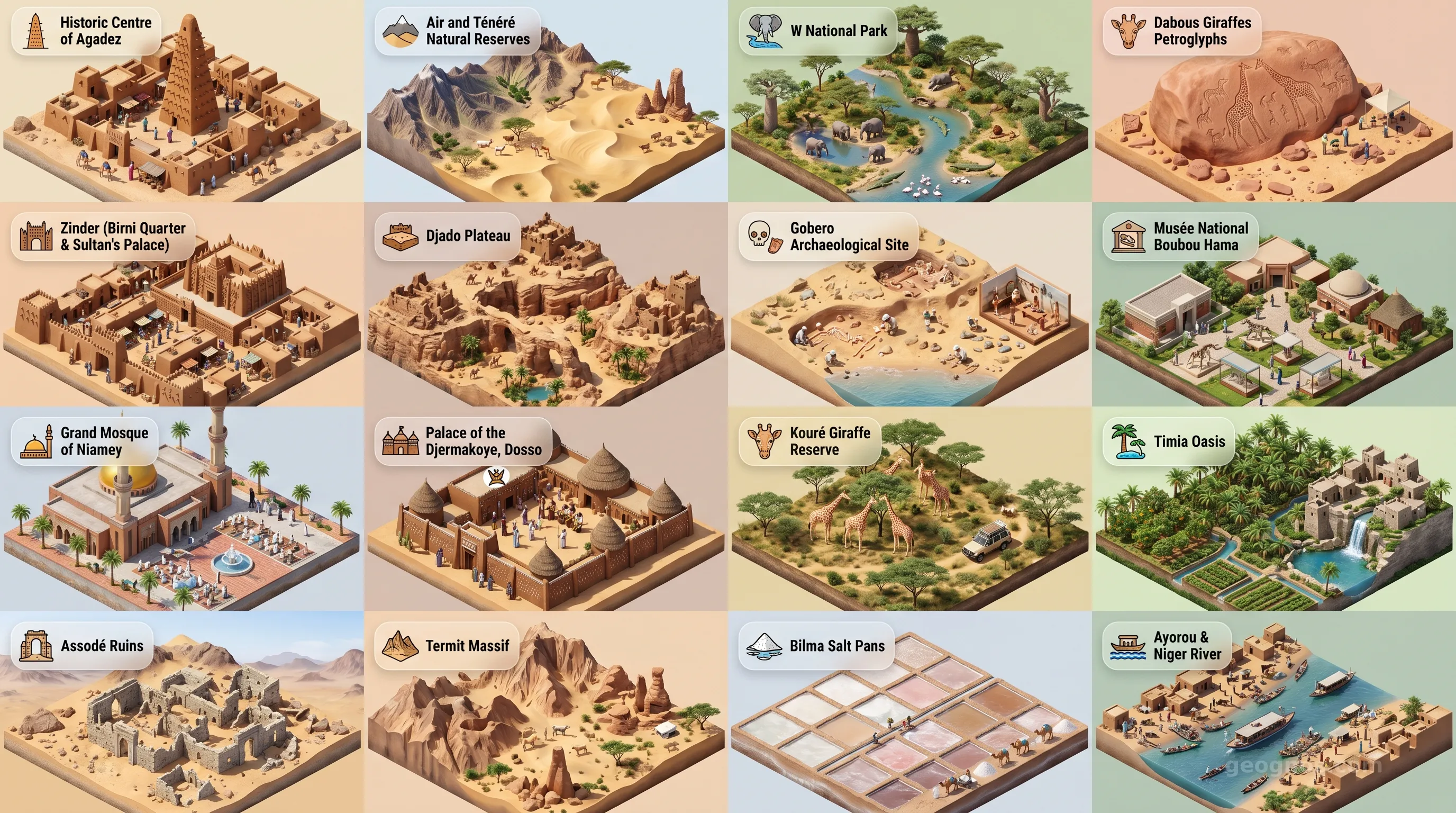
Niger - Panoramic Places of Interest Atlas including Historic Centre of Agadez, Air and Ténéré Natural Reserves, W National Park, Dabous Giraffes Petroglyphs, Zinder (Birni Quarter & Sultan's Palace), Djado Plateau, Gobero Archaeological Site, Musée National Boubou Hama, Grand Mosque of Niamey, Palace of the Djermakoye, Dosso, Kouré Giraffe Reserve, Timia Oasis, Assodé Ruins, Termit Massif, Bilma Salt Pans, Ayorou & Niger River

Top Sights & Landmarks

01

Historic Centre of Agadez

Gateway to the Desert

02

Air and Ténéré Natural Reserves

Africa's Largest Protected Area

03

W National Park

Transnational Biosphere Reserve

04

Dabous Giraffes Petroglyphs

Neolithic Rock Art Masterpiece

05

Zinder (Birni Quarter & Sultan's Palace)

Capital of the Former Sultanate

06

Djado Plateau

Ghost Cities of the Sahara

07

Gobero Archaeological Site

Oldest Graveyard in the Sahara

08

Musée National Boubou Hama

Cultural Heart of Niamey

09

Grand Mosque of Niamey

Modern Islamic Architecture

10

Palace of the Djermakoye, Dosso

Royal Seat of the Djerma People

11

Kouré Giraffe Reserve

Home of the Last West African Giraffes

12

Timia Oasis

The Lush Jewel of the Air Mountains

13

Assodé Ruins

Oldest Town in the Air Mountains

14

Termit Massif

Jagged Peaks and Desert Wildlife

15

Bilma Salt Pans

End of the Azalai Caravan Route

16

Ayorou & Niger River

River Island Life and Hippos

The Heart of the Sahara: Niger's Silent Sovereignty

To stand upon the sands of Niger is to witness the Earth in its most primordial state. It is a land defined by the infinite horizon, where the shifting dunes of the Ténéré Desert communicate in whispers with the distant, life-giving waters of the Niger River. This is a nation of profound contrasts, bridging the divide between the Saharan vastness and the fertile cradle of sub-Saharan life. It is not merely a place on a map; it is a tapestry woven from nomadic threads, ancient trade routes, and a resilience that has outlasted empires.

For centuries, this landscape served as the great crossroads of the Sahel. Traders, scholars, and travelers moved across its northern stretches, connecting the Mediterranean world with the wealthy empires of West Africa. The history of this interaction is vast, spanning eras of immense change and cultural evolution. To gain a deeper understanding of these transformative periods, we invite you to explore the history of Niger, a narrative that paints a portrait of resilience in the face of arid climates and historical upheaval.

A Chronicle of Sand and Spirit

Niger is a land of memory. Every rocky outcrop in the Aïr Mountains and every dried riverbed tells a story of a time when the Sahara was a green, lush corridor for early humanity. As you traverse the chronicles of the region, it becomes clear that Niger's past is as complex as the dunes are fluid. We have curated a sophisticated set of resources to bring this narrative to life. You can deepen your engagement with our interactive modules by testing your chronological knowledge in the history puzzle, a challenging exercise designed to sharpen your historical insight while earning badges for your commitment to mastery.

Visualizing these chapters is vital for those who wish to appreciate the country beyond its cartographic lines. Through the history cinematic showcase, we provide an evocative window into the top historical events that shaped the nation, pairing period illustrations with pedagogical guides that assist both students and educators in connecting past actions to contemporary realities.

The Living Geography of the Sahel

While the image of the golden desert often dominates the Western perception of Niger, the reality is far more textured. The southern fringes of the nation are defined by the Niger River, the country’s namesake, which acts as a lifeline for agriculture, trade, and biodiversity. Here, the landscape transitions from the inhospitable north to a savannah characterized by vibrant community life and the bustle of agrarian centers. The unique character of Niger’s terrain fosters an environment where culture and environment are inextricable, creating a landscape that demands respect and observation.

From the towering, isolated spires of the Aïr Massif to the bustling, mud-brick architectural wonders of Agadez, the physical diversity of the country is as vast as its territory. Those planning an educational excursion or simply wishing to see the natural and architectural grandeur of the land can navigate through our collection of sites. We encourage you to immerse yourself in our POI cinematic showcase, which plays a sequence of high-resolution images and descriptive accounts of Niger's most remarkable geographical and cultural points of interest.

A Cultural Crossroads of the Sahel

The demographic makeup of Niger is a vibrant mosaic. The Hausa, Djerma-Songhai, Tuareg, Fulani, and Kanuri people all contribute to a collective identity that prioritizes hospitality, or "la parenté à plaisanterie," a unique social system that uses humor and kinship ties to maintain peace and community cohesion. In this setting, the oral tradition remains a powerful vehicle for education, passed down through generations beneath the vast expanse of the Sahelian night sky.

Education within Niger is a pursuit marked by significant effort, with local universities and K-12 systems integrating the wisdom of ancestral knowledge with modern scientific inquiry. For the student, Niger represents a living laboratory. Whether you are analyzing the sustainable agricultural practices emerging from the Niger River Basin or studying the migration patterns of nomadic populations in the north, the nation provides an essential case study for understanding how humans adapt to the most extreme environments on our planet.

Looking Toward the Horizon

As the 21st century progresses, Niger stands as a beacon of emerging potential. With a demographic that is among the youngest in the world, the focus of the nation shifts increasingly toward technological integration, infrastructure development, and the sustainable harnessing of its natural resources. The GeoGnos commitment is to provide you with the tools to understand this evolution. As we break down the various administrative and economic structures of this nation in our forthcoming sections, remember that Niger is best understood through its spirit, its geography, and its unyielding capacity for transformation.

The chapters that follow—covering the environmental indicators, political frameworks, and economic indicators of the region—serve as the building blocks for a deeper scholarly engagement. Let the arid, windswept dunes be your teacher, and the flow of the Niger River be your guide as you navigate the complex, rewarding, and undeniably essential landscape of one of Africa’s most fascinating nations.
Location

Latitude
16° N
Longitude
8° E
N S W E
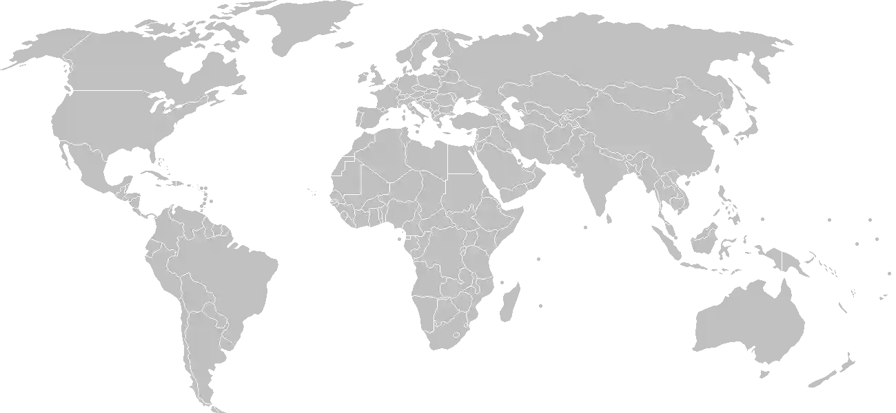
World Map Location
Geographic Location

Western Africa, southeast of Algeria

Map Reference
Africa

Area

Total Area
1.267 million sq km
Land (100%)
Land: 1,266,700 sq km
Water: 300 sq km

Elevation

Highest Point
Idoukal-n-Taghes
Idoukal-n-Taghes 2,022 m
Lowest Point
Niger River
Niger River 200 m
Mean Elevation
474 m

Detailed Geography Information

Coastline

0 km (landlocked)

Geography - note

landlocked; one of the hottest countries in the world; northern four-fifths is desert, southern one-fifth is savanna that is suitable for livestock and limited agriculture

Irrigated land

2,881 sq km (2022)

Land boundaries

Total boundary: 5,834 km
Algeria 951 km
Benin 277 km
Chad 1196 km
Libya 342 km
Mali 838 km
Nigeria 1608 km

Major aquifers

Lake Chad Basin, Lullemeden-Irhazer Basin, Murzuk-Djado Basin

Major lakes (area sq km)

fresh water lake(s): Lake Chad (endorheic lake shared with Chad, Nigeria, and Cameroon) - 10,360-25,900 sq km note - area varies by season and year to year

Major rivers (by length in km)

Niger (shared with Guinea [s], Mali, Benin, and Nigeria [m]) - 4,200 km note: [s] after country name indicates river source; [m] after country name indicates river mouth

Major watersheds (area sq km)

Atlantic Ocean drainage: Niger (2,261,741 sq km) Internal (endorheic basin) drainage: Lake Chad (2,497,738 sq km)

Maritime claims

none (landlocked)

Natural hazards

recurring droughts

Natural resources

uraniumcoaliron oretinphosphatesgoldmolybdenumgypsumsaltpetroleum

Terrain

predominately desert plains and sand dunes; flat to rolling plains in south; hills in north

Population & Growth

+3.70% Growth
27,322,555
Total inhabitants (2025 est.)
Male: 49.6% (13,542,629) Female: 50.4% (13,779,926)

Age Distribution

0-14 years
49.5%
~13,524,665
15-64 years
47.8%
~13,060,181
65 years
2.7%
~737,709
Note: 2024 est.

Demographic Longevity

Median Age
15.3 years
Male
14.9 yrs
Female
15.6 yrs
Life Expectancy
60.9 years
Male
59.3 yrs
Female
62.5 yrs

Vital Dynamics

Birth Rate
46.29
births per 1,000 people
Death Rate
9.24
deaths per 1,000 people
Net Migration
-0.57
migrants per 1,000 people
Fertility Rate
6.55
children born per woman

Detailed People & Society Information

Alcohol consumption per capita

0.11 liters of pure alcohol (2019 est.)

Children under the age of 5 years underweight

34.6% (2022 est.)

Currently married women (ages 15-49)

81.3% (2021 est.)

Dependency ratios

total dependency ratio: 108.2 (2025 est.) youth dependency ratio: 102.6 (2025 est.) elderly dependency ratio: 5.7 (2025 est.) potential support ratio: 17.7 (2025 est.)

Education expenditure

4.1%

4.1% of GDP (2023 est.) 12.8% national budget (2023 est.)

Ethnic groups

Hausa
53.1%
Zarma/Songhai
21.2%
Tuareg
11%
Fulani
6.5%
Kanuri
5.9%
Gurma
0.8%
Arab
0.4%
Tubu
0.4%
other/unavailable
0.9%

Gross reproduction rate

3.23 (2025 est.)

Health expenditure

5.8%

5.8% of GDP (2021) 7.1% of national budget (2022 est.)

Hospital bed density

0.3 beds/1,000 population (2020 est.)

Infant mortality rate

total: 63 deaths/1,000 live births (2025 est.) male: 69.2 deaths/1,000 live births female: 59.2 deaths/1,000 live births

Languages

Literacy

total population: 35.6% (2022 est.) male: 47.9% (2022 est.) female: 25.7% (2022 est.)

Major urban areas - population

1.437 million NIAMEY (capital) (2023)

Maternal mortality ratio

350 deaths/100,000 live births (2023 est.)

Mother's mean age at first birth

18.5 years (2012 est.) note: data represents median age at first birth among women 20-49

Nationality

noun: Nigerien(s) adjective: Nigerien

Obesity - adult prevalence rate

5.5% (2016)

Physician density

0.04 physicians/1,000 population (2023)

Population distribution

majority of the populace is located in the southernmost extreme of the country along the border with Nigeria and Benin, as shown in this population distribution map

Refugees and internally displaced persons

Total Displaced & Vulnerable Persons
1,313,360 individuals
Refugees
32.1%
421,795
421,795 (2024 est.)
Internally Displaced Persons (IDPs)
67.9%
891,565
891,565 (2024 est.)

Religions

Muslim
95.5%
ethnic religionist
4.1%
Christian
0.3%
agnostics and other
0.1%

School life expectancy (primary to tertiary education)

total: 6 years (2017 est.) male: 7 years (2017 est.) female: 6 years (2017 est.)

Sex ratio

at birth: 1.03 male(s)/female 0-14 years: 1.02 male(s)/female 15-64 years: 0.95 male(s)/female 65 years and over: 0.92 male(s)/female total population: 0.98 male(s)/female (2024 est.)

Tobacco use

total: 7.5% (2025 est.) male: 13.7% (2025 est.) female: 1.2% (2025 est.)

Climate & Issues

Climate Profile

desert; mostly hot, dry, dusty; tropical in extreme south

Key Environmental Issues
overgrazing soil erosion deforestation desertification contaminated water inadequate potable water wildlife populations (such as elephant, hippopotamus, giraffe, and lion) threatened by poaching and habitat destruction

Land Cover

Coverage Distribution
Agri (37%)
Other (62%)
Arable: 14.0%
Crops: 0.1%
Pasture: 22.7%
Forest: 0.8%

Air & Carbon Emissions

Annual CO2 Output 2023 est.
3.132 million
Coal (92%) Oil (0%) Gas (8%)
PM2.5 Exposure 59.5 µg/m³
0 5 (WHO Limit) 15 25 35+
Methane Emissions
energy: 137.8 kt (2022-2024 est.)

Water Resources & Use

Renewable Water Resources 34,050,000,000 cubic meters (2022 est.)
Annual Water Withdrawal
municipal: 193.247 million cubic meters (2022 est.)
Municipal (7%) Ind (1%) Agri (91%)

Detailed Environmental Information

International environmental agreements

BiodiversityClimate ChangeClimate Change-Kyoto ProtocolClimate Change-Paris AgreementComprehensive Nuclear Test BanDesertificationEndangered SpeciesEnvironmental ModificationHazardous WastesLaw of the SeaNuclear Test BanOzone Layer ProtectionWetlands

Urbanization

urban population: 17.1% of total population (2023) rate of urbanization: 4.72% annual rate of change (2020-25 est.)

Waste and recycling

municipal solid waste generated annually: 1.866 million tons (2024 est.) percent of municipal solid waste recycled: 20.3% (2022 est.)

Capital & State Profile

Capital City
Niamey
13.5167° N, 2.1167° E
Timezone UTC+1
Government Type
formerly, semi-presidential republic Note: on 26 July 2023, the National Council for the Safeguard of the Homeland, a military junta which took control of Niger's government, dissolved all government institutions, and rules by decree
Independence 1960-08-03
National Holiday 12-18

Executive Branch

Chief of State
President of the National Council for the Safeguard of the Homeland (CNSP) General Abdourahame TIANI
Head of Government
CNSP Prime Minister Ali Mahaman Lamine ZEINE (since 9 August 2023)
Last Election 27 December 2020, with a runoff held on 21 February 2021
Next Election 2030
Cabinet Cabinet appointed by the CNSP

Legislative Branch

unicameral
Legislature Name Advisory Council for the Refoundation (Conseil consultatif de la refondation)
Seats & Term
194 (all appointed) seats / N/A
Women in Chamber
19.6% Representation
Electoral System mixed system

National Identity & Symbols

National Flag Description

three equal horizontal bands of orange (top), white, and green, with an orange disk centered on the white band

Symbolic Meaning orange stands for the northern Sahara regions, white for purity and innocence, and green for hope and the fertile and productive southern and western areas, as well as the Niger River; the orange disc represents the sun and the people's sacrifices
National Symbol zebu
National Colors orange, white, green
National Anthem LHonneur de la Patrie (The Honor of the Fatherland)

Detailed Government Information

Administrative divisions

7 regions (régions, singular - région) and 1 capital district* (communauté urbaine); Agadez, Diffa, Dosso, Maradi, Niamey*, Tahoua, Tillaberi, Zinder

Citizenship

citizenship by birth: no citizenship by descent only: at least one parent must be a citizen of Niger dual citizenship recognized: yes residency requirement for naturalization: unknown

Constitution

history: several previous; passed by referendum 31 October 2010, entered into force 25 November 2010 amendment process: formerly proposed by the president of the republic or the National Assembly; consideration of amendments requires at least three-fourths majority vote by the Assembly; passage requires at least four-fifths majority vote; if disapproved, the proposed amendment is dropped or submitted to a referendum; constitutional articles on the form of government, the multiparty system, the separation of state and religion, disqualification of Assembly members, amendment procedures, and amnesty of participants in the 2010 coup cannot be amended note: on 26 July 2023, the National Council for the Safeguard of the Homeland, a military junta which took control of Niger's government, dissolved the country's constitution

Country name

conventional long form: Republic of Niger conventional short form: Niger local long form: République du Niger local short form: Niger etymology: named for the Niger River that passes through the southwest of the country; the name of the river probably comes from the local Tuareg name, egereou n-igereouen (big rivers) note: pronounced nee-ZHAIR

International law organization participation

has not submitted an ICJ jurisdiction declaration; accepts ICCt jurisdiction

International organization participation

Judicial branch

highest court(s): High Court of Justice (consists of 7 members); Supreme Court (membership NA); Constitutional Court (consists of 7 judges) judge selection and term of office: High Judicial Court members selected from among the legislature and judiciary to 5-year terms; Constitutional Court judges nominated/elected - 1 by the president of the Republic, 1 by the president of the National Assembly, 2 by peer judges, 2 by peer lawyers, 1 law professor by peers, and 1 from within Nigerien society; all appointed by the president; judges serve 6-year nonrenewable terms with one-third of membership renewed every 2 years subordinate courts: Court of Cassation; Council of State; Court of Finances; various specialized tribunals and customary courts

Legal system

note: following the 26 July 2023 military coup, the National Council for the Safeguard of the Homeland assumed control of all government institutions and rules by decree; formerly, mixed system of civil law, based on French civil law, Islamic law, and customary law

National heritage

total World Heritage Sites: 3 (1 cultural, 2 natural) selected World Heritage Site locales: Air and Ténéré Natural Reserves (n); W-Arly-Pendjari Complex (n); Historic Agadez (c)

Political parties

Alliance for Democracy and the Republic Alliance for Democratic Renewal or ARD-Adaltchi-Mutuntchi Alliance of Movements for the Emergence of Niger or AMEN AMIN Congress for the Republic or CPR-Inganci Democratic Alternation for Equity in Niger Democratic and Republican Renewal-RDR-Tchanji Democratic Movement for the Emergence of Niger Falala Democratic Patriots' Rally or RPD Bazara National Movement for the Development of Society-Nassara or MNSD-Nassara Nigerien Alliance for Democracy and Progress-Zaman Lahiya or ANDP-Zaman Lahiya Nigerien Democratic Movement for an African Federation or MODEN/FA Lumana Nigerien Party for Democracy and Socialism or PNDS-Tarrayya Nigerien Patriotic Movement or MPN-Kishin Kassa Nigerien Rally for Democracy and Peace Patriotic Movement for the Republic or MPR-Jamhuriya Peace, Justice, Progress–Generation Doubara Rally for Democracy and Progress-Jama'a or RDP-Jama'a Rally for Peace and Progress or RPP Farilla Social Democratic Rally or RSD-Gaskiyya Social Democratic Party or PSD-Bassira note: after the 26 July 2023 military coup, the National Council for the Safeguard of the Homeland dissolved the National Assembly and prohibited all political party activity

Suffrage

18 years of age; universal

Economic Overview

low-income Sahel economy; major instability and humanitarian crises limit economic activity; COVID-19 eliminated recent antipoverty gains; economy rebounding since December 2020 Nigerian border reopening and new investments; uranium resource rich

Size & Performance

Real GDP (PPP)
$47.921 billion
Latest available estimate (2024)
2023: $44.199 billion2022: $43.474 billion
Real GDP Growth
8.4% (2024 est.)
+8.4%
GDP Per Capita (PPP)
$1,800
2023: $1,7002022: $1,700

GDP Sector Breakdown

Agriculture: 33.8%Industry: 17.8%Services: 45.4%
Origin GDP %
Agriculture 33.8%
Industry 17.8%
Services 45.4%

Trade Balance

Trade Position
Trade Deficit
$2.58 billion
Total Exports
$1.223 billion (2023 est.)
Total Imports
$3.808 billion (2023 est.)
Exports (24%) Imports (76%)

Budget Balance

Budget Position
Budget Deficit
-$460.00 million
Revenues
$2.325 billion (2019 est.)
Expenditures
$2.785 billion (2019 est.)
Revenues (45%) Expenditures (55%)

Export Profile

Top Export Partners

31.0%
23.0%
18.0%
6.0%
Note: 2023; top five export partners based on percentage share of exports

Major Export Commodities

goldoil seedsuranium and thorium oreradioactive chemicalsrefined petroleum

Import Profile

Top Import Partners

26.0%
15.0%
12.0%
6.0%
Note: 2023; top five import partners based on percentage share of imports

Major Import Commodities

riceaircraft partsiron structuresrefined petroleumcentrifuges

Labor & Employment

Total Labor Force 10.486 million (2024 est.)
General Unemployment Rate 0.4%
Youth Unemployment (Ages 15-24) 0.3%
Population Below Poverty Line 45.5% (2021 est.)

Income Inequality

Gini Coefficient (Family Income) 32.9
0 (Perfect Equality) Moderate Inequality 100 (Perfect Inequality)

Family Income / Consumption Share

Lowest 10%: 3.8% (2021 est.) Highest 10%: 27.8% (2021 est.)
Inequality Gap: Top 10% holds 7.3x the share of the bottom 10%.

Detailed Economic Data

Agricultural products

milletcowpeassorghumonionsmilksugarcanecabbagescassavagroundnutstomatoes

Current account balance

-$2.333 billion (2023 est.) -$2.5 billion (2022 est.) -$2.099 billion (2021 est.) note: balance of payments - net trade and primary/secondary income in current dollars

Debt - external

$3.793 billion (2023 est.) note: present value of external debt in current US dollars

Exchange rates

Communaute Financiere Africaine francs (XOF) per US dollar - Exchange rates: 606.345 (2024 est.) 606.57 (2023 est.) 623.76 (2022 est.) 554.531 (2021 est.) 575.586 (2020 est.)

GDP - composition, by end use

Industrial production growth rate

12.1% (2024 est.) note: annual % change in industrial value added based on constant local currency

Industries

uranium miningpetroleumcementbricksoaptextilesfood processingchemicalsslaughterhouses

Inflation rate (consumer prices)

9.1% (2024 est.) 3.7% (2023 est.) 4.2% (2022 est.) note: annual % change based on consumer prices

Remittances

3.7% of GDP (2023 est.) 4.7% of GDP (2022 est.) 2.4% of GDP (2021 est.) note: personal transfers and compensation between resident and non-resident individuals/households/entities

Grid Infrastructure

Electricity Access 19.5%
Urban: 66.1% Rural: 7.7%
Capacity 377,000 kW (2023 est.)
Consumption 1.645 billion kWh (2023 est.)
Imports 1.213 billion kWh (2023 est.)
Grid Losses: 372.245 million kWh (2023 est.)

Generation Mix

Percentage Share of Production
fossil fuels 97%
solar 3%

Fossil Fuels Production

Petroleum
Production 13,000 bbl/day (2023 est.)
Consumption 18,000 bbl/day (2023 est.)
Proven Reserves 150 million barrels (2021 est.)
Natural Gas
Production 26.805 million cubic meters (2023 est.)
Consumption 26.872 million cubic meters (2023 est.)
Coal
Production 427,000 metric tons (2023 est.)
Consumption 426,000 metric tons (2023 est.)
Imports 400 metric tons (2023 est.)
Proven Reserves 90 million metric tons (2023 est.)

Intensity & Nuclear

Energy Consumption Per Capita 1.772 million Btu/person (2023 est.)
No nuclear energy infrastructure or reactor operations reported in this country dossier.

Digital Access

.ne
Internet Usage 23%

Active internet users as a percentage of the total population.

Fixed Broadband

Penetration Rate 0 / 100
Total Subscriptions 14,000 (2022 est.)

Mobile Cellular

Penetration Rate 66 / 100
Total Subscriptions 17.2 million (2023 est.)

Broadcast Media

state-run TV station; 3 private TV stations provide a mix of local and foreign programming; state-run radio has the only radio station with national coverage; about 30 private local radio stations; as many as 100 community radio stations; transmissions of multiple international broadcasters are available

Aviation

5U
Airports
26
As of 2025

Military Expenditures

GDP Allocation 2.2%
2.2% of GDP (2024 est.) 2% of GDP (2023 est.) 1.7% of GDP (2022 est.) 1.8% of GDP (2021 est.) 2% of GDP (2020 est.)

Active Duty Strengths

estimated 50,000 active Armed Forces, including Gendarmerie; estimated 15-20,000 National Guard (2025) note: in 2020, the Nigerien Government announced it intended to increase the size of the FAN to 50,000 by 2025 and 100,000 by 2030

Refers to active military personnel.

Service & Defense Details

Military and security forces

Nigerien Armed Forces (Forces Armees Nigeriennes, FAN): Army, Nigerien Air Force, Niger Gendarmerie Ministry of Interior, Public Safety and Decentralization: Niger National Guard, National Police (2025) note 1: the Niger Gendarmerie (GN) and the Niger National Guard (GNN) are paramilitary forces; the GN has primary responsibility for rural security while the GNN is responsible for domestic security and the protection of high-level officials and government buildings note 2: the Directorate of Territorial Surveillance under the National Police is charged with border management

Military equipment inventories and acquisitions

the FAN's inventory is comprised of older, typically Soviet-era weapons and equipment, along with smaller quantities of more modern armaments such as unmanned aerial vehicles/drones, air defense systems, and armored vehicles; suppliers over the past decade include China, France, Russia, South Africa, Türkiye, and the US (2025)

Military - note

the military of Niger is responsible for territorial defense, but most of its focus is on internal and border security operations; the Islamic State of Iraq and ash-Sham in the Greater Sahara (ISIS-GS) and the al-Qaida affiliate Jama’at Nusrat al-Islam wal-Muslimin (JNIM) terrorist groups are active in western Niger and in adjacent strongholds in Burkina Faso and Mali, while the Nigeria-based Boko Haram and ISIS-West Africa groups threaten southeast Niger; parts of Niger also face spillover from communal, criminal, and vigilante violence in neighboring Nigeria; since the 2023 coup, some former ethnic separatist rebels have taken up arms in support of deposed President BAZOUM the military has played a role in Niger's domestic politics since its establishment in 1960-61; prior to seizing control of the government in 2023, it attempted coups in 1974, 1996, 1999, 2010, and 2021, and ruled the country for much of the period before 1999 (2025)

Military service age and obligation

18 is the legal minimum age for selective compulsory or voluntary military service for unmarried men and women; 24-month service term (2025)