🇲🇱

Mali

Africa • Countries
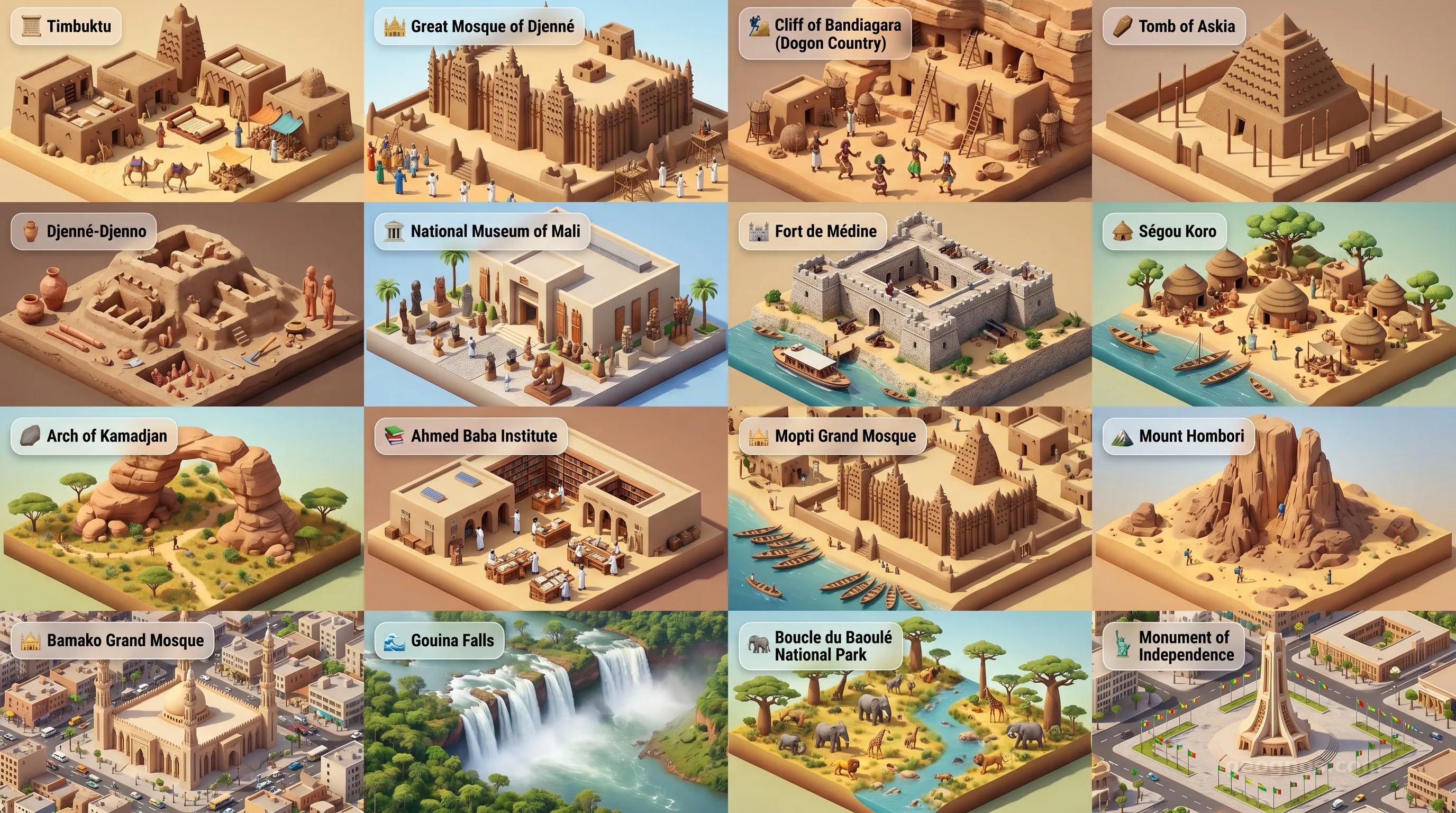
Mali - Panoramic Places of Interest Atlas including Timbuktu, Great Mosque of Djenné, Cliff of Bandiagara (Dogon Country), Tomb of Askia, Djenné-Djenno, National Museum of Mali, Fort de Médine, Ségou Koro, Arch of Kamadjan, Ahmed Baba Institute, Mopti Grand Mosque, Mount Hombori, Bamako Grand Mosque, Gouina Falls, Boucle du Baoulé National Park, Monument of Independence

Top Sights & Landmarks

01

Timbuktu

The City of 333 Saints

02

Great Mosque of Djenné

World's Largest Mud-Brick Building

03

Cliff of Bandiagara (Dogon Country)

Mystical Escarpment of the Dogon People

04

Tomb of Askia

Pyramidal Monument of the Songhai Empire

05

Djenné-Djenno

Ancient Sub-Saharan Metropolis

06

National Museum of Mali

Custodian of Malian Heritage

07

Fort de Médine

Relic of Anti-Colonial Resistance

08

Ségou Koro

Old Capital of the Bamana Empire

09

Arch of Kamadjan

Natural Arch of the Manding Empire

10

Ahmed Baba Institute

Preserver of Desert Manuscripts

11

Mopti Grand Mosque

The Mud-Brick Jewel of the Venice of Mali

12

Mount Hombori

Mali's Highest Peak

13

Bamako Grand Mosque

Spiritual Hub of the Capital

14

Gouina Falls

The Niagara Falls of Mali

15

Boucle du Baoulé National Park

Biosphere Reserve and Prehistoric Rock Art

16

Monument of Independence

Symbol of Malian Sovereignty

The Golden Pulse of the Sahel

To speak of Mali is to speak of the memory of the earth. Stretching across the vast expanse of West Africa, Mali is a landscape defined by the duality of the relentless, sun-scorched Sahara and the life-giving, rhythmic pulse of the Niger River. It is a nation that does not merely occupy a space on a map, but rather anchors the human experience in the heart of the continent. For centuries, this region served as the great meeting place of humanity, where gold, salt, manuscripts, and ideas flowed across the dunes like tides in a sea of sand. To understand Mali is to engage with a civilization that shaped global commerce and intellectual thought long before the modern era, leaving behind a legacy that still breathes in the music, architecture, and resilient spirit of its people.

An Empire Forged in the Sands

The historical gravity of Mali is immense, rooted in the rise of legendary empires that stood as pillars of the medieval world. From the expansive glory of the Ghana Empire to the incomparable reach of the Mali Empire, and finally the scholarly pinnacle of the Songhai, this land was the site of a profound cultural flourishing. Timbuktu became the intellectual heartbeat of the continent, attracting scholars and architects whose mud-brick mosques continue to defy the ages as icons of human ingenuity. To truly comprehend the foundational events that defined this land, you should explore the history of Mali. It is a narrative that moves from the oral traditions of the griots to the sophisticated court of Mansa Musa, the king who famously traveled to Cairo with enough gold to influence the economy of an entire region for decades.

Mastering the Chronology of Legends

History in Mali is rarely just about dates; it is about sequences of influence and shifts in power that stretched across continents. As educators and students alike seek to grasp the complexity of these transitions, our platform provides a bridge to understanding. Whether you are mapping the lineage of the Keita dynasty or the fall and rise of regional centers, you can test your knowledge by participating in our history puzzle. By arranging the defining moments of this great civilization in their proper order, you engage with the narrative structure of West Africa and earn your place within our community of explorers.

A Visual Tapestry of Civilizations

While the written word provides a roadmap, the visual impact of Mali is impossible to overstate. There is an ethereal quality to the way the sun hits the adobe walls of the Great Mosque of Djenne or the shifting patterns of the dunes in the Tanezrouft. We believe that history is a visual medium that speaks to the senses, which is why we invite you to view our history cinematic showcase. This curated collection brings the key chapters of Mali's past to life through evocative imagery and historical narratives that transform flat text into a vivid experience of ancient splendor.

Beyond the Horizon: The Modern Soul of Mali

Travelers today often seek to experience the soul of a nation, and in Mali, that soul is found in the interplay between its natural wonders and the points of contact where the past meets the present. From the dramatic cliffs of the Bandiagara Escarpment, where the Dogon people have carved a unique existence into the rock face, to the bustling, vibrant markets of Bamako, the country is a living museum. To prepare for a journey through these landscapes, you can immerse yourself in our POI cinematic showcase. This collection highlights the diverse geographical and cultural landmarks that define Mali's contemporary geography.

The Geographical Pulse of a Nation

The geographical reality of Mali is defined by the transition from the arid, windswept Sahara in the north to the fertile Sudanese savanna in the south. The Niger River functions as the central artery, sustaining agriculture, transport, and community life. This seasonal movement of water dictates the rhythm of the year, influencing the lives of the millions who dwell along its banks. Mali stands as a testament to human adaptation, a place where people have successfully navigated one of the world's most challenging environments to create a society rich in tradition, warmth, and artistic depth. Whether viewed through the lens of a researcher studying climate patterns or a student discovering the architectural beauty of the desert, Mali remains an indispensable piece of the world atlas, inviting everyone to learn more about the deep, golden history embedded within its soil.
Location

Latitude
17° N
Longitude
-4° E
N S W E
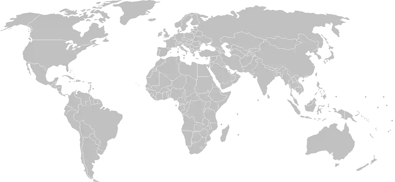
World Map Location
Geographic Location

interior Western Africa, southwest of Algeria, north of Guinea, Cote d'Ivoire, and Burkina Faso, west of Niger

Map Reference
Africa

Area

Total Area
1,240,192 sq km
Land (98%)
Land: 1,220,190 sq km
Water: 20,002 sq km

Elevation

Highest Point
Hombori Tondo
Hombori Tondo 1,155 m
Lowest Point
Senegal River
Senegal River 23 m
Mean Elevation
343 m

Detailed Geography Information

Coastline

0 km (landlocked)

Geography - note

landlocked; divided into three natural zones: the southern, cultivated Sudanese; the central, semiarid Sahelian; and the northern, arid Saharan

Irrigated land

3,780 sq km (2012)

Land boundaries

Total boundary: 7,908 km
Algeria 1359 km
Burkina Faso 1325 km
Guinea 1062 km
Mauritania 2236 km
Niger 838 km
Senegal 489 km

Major aquifers

Lullemeden-Irhazer Basin, Taodeni-Tanezrouft Basin

Major lakes (area sq km)

fresh water lake(s): Lac Faguibine - 590 sq km note - the Niger River is the only source of water for the lake; in recent years the lake is dry

Major rivers (by length in km)

Niger (shared with Guinea [s], Niger, and Nigeria [m]) - 4,200 km; Senegal (shared with Guinea [s], Senegal, and Mauritania [m]) - 1,641 km note: [s] after country name indicates river source; [m] after country name indicates river mouth

Major watersheds (area sq km)

Atlantic Ocean drainage: Niger (2,261,741 sq km), Senegal (456,397 sq km), Volta (410,991 sq km)

Maritime claims

none (landlocked)

Natural hazards

hot, dust-laden harmattan haze common during dry seasons; recurring droughts; occasional Niger River flooding

Natural resources

goldphosphateskaolinsaltlimestoneuraniumgypsumgranitehydropower

Terrain

mostly flat to rolling northern plains covered by sand; savanna in south, rugged hills in northeast

Population & Growth

+2.90% Growth
22,634,423
Total inhabitants (2025 est.)
Male: 48.6% (10,999,331) Female: 51.4% (11,635,092)

Age Distribution

0-14 years
46.8%
~10,592,910
15-64 years
50.1%
~11,339,846
65 years
3.1%
~701,667
Note: 2024 est.

Demographic Longevity

Median Age
16.5 years
Male
15.7 yrs
Female
17.1 yrs
Life Expectancy
63.2 years
Male
60.9 yrs
Female
65.6 yrs

Vital Dynamics

Birth Rate
39.44
births per 1,000 people
Death Rate
7.87
deaths per 1,000 people
Net Migration
-2.82
migrants per 1,000 people
Fertility Rate
5.26
children born per woman

Detailed People & Society Information

Alcohol consumption per capita

0.6 liters of pure alcohol (2019 est.)

Children under the age of 5 years underweight

15% (2024 est.)

Currently married women (ages 15-49)

79.2% (2018 est.)

Dependency ratios

total dependency ratio: 98.5 (2025 est.) youth dependency ratio: 92.3 (2025 est.) elderly dependency ratio: 6.2 (2025 est.) potential support ratio: 16.2 (2025 est.)

Education expenditure

4.2%

4.2% of GDP (2023 est.) 17.8% national budget (2024 est.)

Ethnic groups

Bambara
33.3%
Fulani
13.3%
Sarakole/Soninke/Marka
9.8%
Senufo/Manianka
9.6%
Malinke
8.8%
Dogon
8.7%
Sonrai
5.9%
Bobo
2.1%
Tuareg/Bella
1.7%
other Malian
6%
from members of Economic Community of West Africa
0.4%
other
0.3%

Gross reproduction rate

2.59 (2025 est.)

Health expenditure

4.5%

4.5% of GDP (2021) 5.7% of national budget (2022 est.)

Hospital bed density

0.2 beds/1,000 population (2018 est.)

Infant mortality rate

total: 55.8 deaths/1,000 live births (2025 est.) male: 62.6 deaths/1,000 live births female: 52 deaths/1,000 live births

Languages

French
17.2%
Peuhl/Foulfoulbe/Fulani
9.4%
Dogon
7.2%
Maraka/Soninke
6.4%
Malinke
5.6%
Sonrhai/Djerma
5.6%
Minianka
4.3%
Tamacheq
3.5%
Senoufo
2.6%
Bobo
2.1%
other
6.3%
unspecified
0.7%

Literacy

total population: 35.5% (2018 est.) male: 46.2% (2018 est.) female: 25.7% (2018 est.)

Major urban areas - population

2.929 million BAMAKO (capital) (2023)

Maternal mortality ratio

367 deaths/100,000 live births (2023 est.)

Mother's mean age at first birth

19.2 years (2018 est.) note: data represents median age at first birth among women 20-49

Nationality

noun: Malian(s) adjective: Malian

Obesity - adult prevalence rate

8.6% (2016)

Physician density

0.19 physicians/1,000 population (2023)

Population distribution

the overwhelming majority of the population lives in the southern half of the country, with greater density along the border with Burkina Faso, as shown in this population distribution map

Refugees and internally displaced persons

Total Displaced & Vulnerable Persons
514,190 individuals
Refugees
26.4%
135,827
135,827 (2024 est.)
Internally Displaced Persons (IDPs)
73.6%
378,363
378,363 (2024 est.)

Religions

Muslim
93.9%
Christian
2.8%
animist
0.7%
none
2.5%

School life expectancy (primary to tertiary education)

total: 7 years (2017 est.) male: 8 years (2017 est.) female: 6 years (2017 est.)

Sex ratio

at birth: 1.03 male(s)/female 0-14 years: 1.01 male(s)/female 15-64 years: 0.89 male(s)/female 65 years and over: 0.97 male(s)/female total population: 0.95 male(s)/female (2024 est.)

Tobacco use

total: 6.9% (2025 est.) male: 13.1% (2025 est.) female: 0.6% (2025 est.)

Climate & Issues

Climate Profile

subtropical to arid; hot and dry (February to June); rainy, humid, and mild (June to November); cool and dry (November to February)

Key Environmental Issues
deforestation soil erosion desertification loss of pasture land inadequate supplies of potable water

Land Cover

Coverage Distribution
Agri (36%)
Other (56%)
Arable: 6.8%
Crops: 0.2%
Pasture: 28.4%
Forest: 8.8%

Air & Carbon Emissions

Annual CO2 Output 2023 est.
6.858 million
Coal (92%) Oil (8%) Gas (0%)
PM2.5 Exposure 48.5 µg/m³
0 5 (WHO Limit) 15 25 35+

Water Resources & Use

Renewable Water Resources 120 billion cubic meters (2022 est.)
Annual Water Withdrawal
municipal: 107 million cubic meters (2022 est.)
Municipal (2%) Ind (0%) Agri (98%)

Detailed Environmental Information

International environmental agreements

BiodiversityClimate ChangeClimate Change-Kyoto ProtocolClimate Change-Paris AgreementComprehensive Nuclear Test BanDesertificationEndangered SpeciesHazardous WastesLaw of the SeaOzone Layer ProtectionTropical Timber 2006WetlandsWhaling

Urbanization

urban population: 46.2% of total population (2023) rate of urbanization: 4.57% annual rate of change (2020-25 est.)

Waste and recycling

municipal solid waste generated annually: 1.937 million tons (2024 est.) percent of municipal solid waste recycled: 10.4% (2022 est.)

Capital & State Profile

Capital City
Bamako
12.65° N, -8° E
Timezone UTC 0
Government Type
semi-presidential republic
Independence 1960-09-22
National Holiday 09-22

Executive Branch

Chief of State
Transition President Assimi GOITA (since 7 June 2021)
Head of Government
Transition Prime Minister Abdoulaye MAIGA (since 22 November 2024)
Last Election 29 July 2018, with runoff on 12 August 2018
Cabinet Council of Ministers appointed by the prime minister

Legislative Branch

unicameral
Legislature Name Transitional National Council (Conseil national de transition)
Seats & Term
147 (all appointed) seats / N/A
Women in Chamber
30.1% Representation
Electoral System plurality/majority

National Identity & Symbols

National Flag Description

three equal vertical bands of green (left side), yellow, and red

Symbolic Meaning history: uses the colors of the Pan-African movement
National Symbol Great Mosque of Djenne
National Colors green, yellow, red
National Anthem Le Mali (Mali)

Detailed Government Information

Administrative divisions

19 regions (régions, singular - région), 1 district*; Bamako*, Bandiagara, Bougouni, Dioila, Douentza, Gao, Kayes, Kidal, Kita, Koulikoro, Koutiala, Menaka, Mopti, Nara, Nioro, San, Segou, Sikasso, Taoudenni, Tombouctou (Timbuktu)

Citizenship

citizenship by birth: no citizenship by descent only: at least one parent must be a citizen of Mali dual citizenship recognized: yes residency requirement for naturalization: 5 years

Constitution

history: several previous; latest drafted 13 October 2022 and submitted to Transition President Assimi GOITA; final draft completed 1 March 2023; approved by referendum 18 June 2023; validated by Constitutional Court 22 July 2023

Country name

conventional long form: Republic of Mali conventional short form: Mali local long form: République de Mali local short form: Mali former: French Sudan, Sudanese Republic, Mali Federation etymology: name derives from the Mali Empire of the 13th to 16th centuries A.D.; the Mali name may come from a local ethnic group, the Malinke, whose name is derived from the words ma, meaning "mother," and dink, meaning "child" -- a reference to the matrilinear descent of Malinke families

International law organization participation

has not submitted an ICJ jurisdiction declaration; accepts ICCt jurisdiction

International organization participation

Judicial branch

highest court(s): Supreme Court or Cour Suprême (consists of 19 judges organized into judicial, administrative, and accounting sections); Constitutional Court (consists of 9 judges) judge selection and term of office: Supreme Court judges appointed by the Ministry of Justice to serve 5-year terms; Constitutional Court judges selected - 3 each by the president, the National Assembly, and the Supreme Council of the Magistracy; members serve single renewable 7-year terms subordinate courts: Court of Appeal; High Court of Justice (jurisdiction limited to cases of high treason or criminal offenses by the president or ministers while in office); administrative courts (first instance and appeal); commercial courts; magistrate courts; labor courts; juvenile courts; special court of state security

Legal system

civil law system based on the French civil law model and influenced by customary law; Constitutional Court reviews legislative acts

National heritage

total World Heritage Sites: 4 (3 cultural, 1 mixed) selected World Heritage Site locales: Old Towns of Djenné (c); Timbuktu (c); Cliff of Bandiagara (Land of the Dogons) (m); Tomb of Askia (c)

Political parties

African Solidarity for Democracy and Independence or SADI Alliance for Democracy and Progress or ADP-Maliba Alliance for Democracy in Mali-Pan-African Party for Liberty, Solidarity, and Justice or ADEMA-PASJ Alliance for the Solidarity of Mali-Convergence of Patriotic Forces or ASMA-CFP Convergence for the Development of Mali or CODEM Democratic Alliance for Peace or ADP-Maliba Movement for Mali or MPM Party for National Renewal (also Rebirth or Renaissance or PARENA) Rally for Mali or RPM Social Democratic Convention or CDS Union for Democracy and Development or UDD Union for Republic and Democracy or URD Yéléma note 1: only parties with 2 or more seats in the last National Assembly parliamentary elections (30 March and 19 April 2020) included note 2: the National Assembly was dissolved on 18 August 2020 following a military coup and replaced with a National Transition Council; currently 121 members, party affiliations unknown

Suffrage

18 years of age; universal

Economic Overview

low-income Saharan economy; recession due to COVID-19 and political instability; extreme poverty; environmentally fragile; high public debt; agricultural and gold exporter; terrorism and warfare are common

Size & Performance

Real GDP (PPP)
$71.253 billion
Latest available estimate (2024)
2023: $67.857 billion2022: $64.8 billion
Real GDP Growth
5% (2024 est.)
+5%
GDP Per Capita (PPP)
$2,900
2023: $2,9002022: $2,800

GDP Sector Breakdown

Agriculture: 33.4%Industry: 22.7%Services: 36.7%
Origin GDP %
Agriculture 33.4%
Industry 22.7%
Services 36.7%

Trade Balance

Trade Position
Trade Deficit
$1.94 billion
Total Exports
$6.13 billion (2023 est.)
Total Imports
$8.066 billion (2023 est.)
Exports (43%) Imports (57%)

Budget Balance

Budget Position
Budget Deficit
-$722.00 million
Revenues
$2.841 billion (2020 est.)
Expenditures
$3.563 billion (2020 est.)
Revenues (44%) Expenditures (56%)

Export Profile

Top Export Partners

Note: 2023; top five export partners based on percentage share of exports

Major Export Commodities

goldcottonoil seedsfertilizersgum resins

Import Profile

Top Import Partners

Note: 2023; top five import partners based on percentage share of imports

Major Import Commodities

refined petroleumbroadcasting equipmentcementcotton fabricplastic products

Labor & Employment

Total Labor Force 9.126 million (2024 est.)
General Unemployment Rate 3.1%
Youth Unemployment (Ages 15-24) 4.0%
Population Below Poverty Line 44.6% (2021 est.)

Income Inequality

Gini Coefficient (Family Income) 35.7
0 (Perfect Equality) Moderate Inequality 100 (Perfect Inequality)

Family Income / Consumption Share

Lowest 10%: 3.2% (2021 est.) Highest 10%: 28.3% (2021 est.)
Inequality Gap: Top 10% holds 8.8x the share of the bottom 10%.

Detailed Economic Data

Agricultural products

maizericemilletsorghumonionsokrasugarcanecottonmangoessweet potatoes

Current account balance

-$1.61 billion (2023 est.) -$1.475 billion (2022 est.) -$1.469 billion (2021 est.) note: balance of payments - net trade and primary/secondary income in current dollars

Debt - external

$4.085 billion (2023 est.) note: present value of external debt in current US dollars

Exchange rates

Communaute Financiere Africaine francs (XOF) per US dollar - Exchange rates: 606.345 (2024 est.) 606.57 (2023 est.) 623.76 (2022 est.) 554.531 (2021 est.) 575.586 (2020 est.)

GDP - composition, by end use

Industrial production growth rate

-2.4% (2024 est.) note: annual % change in industrial value added based on constant local currency

Industries

food processingconstructionphosphate and gold mining

Inflation rate (consumer prices)

3.2% (2024 est.) 2.1% (2023 est.) 9.6% (2022 est.) note: annual % change based on consumer prices

Remittances

4.2% of GDP (2023 est.) 4.9% of GDP (2022 est.) 4.9% of GDP (2021 est.) note: personal transfers and compensation between resident and non-resident individuals/households/entities

Taxes and other revenues

12% (of GDP) (2020 est.) note: central government tax revenue as a % of GDP

Grid Infrastructure

Electricity Access 53%
Urban: 99.7% Rural: 18.3%
Capacity 1.222 million kW (2023 est.)
Consumption 4.261 billion kWh (2023 est.)
Exports 661.63 million kWh (2023 est.)
Imports 880 million kWh (2023 est.)
Grid Losses: 320.616 million kWh (2023 est.)

Generation Mix

Percentage Share of Production
fossil fuels 57.3%
hydroelectricity 37.6%
solar 3.5%
biomass and waste 1.6%

Fossil Fuels Production

Petroleum
Consumption 46,000 bbl/day (2023 est.)
Coal
Imports 36 metric tons (2023 est.)

Intensity & Nuclear

Energy Consumption Per Capita 4.307 million Btu/person (2023 est.)
No nuclear energy infrastructure or reactor operations reported in this country dossier.

Digital Access

.ml
Internet Usage 35%

Active internet users as a percentage of the total population.

Fixed Broadband

Penetration Rate 1 / 100
Total Subscriptions 179,000 (2022 est.)

Mobile Cellular

Penetration Rate 112 / 100
Total Subscriptions 25.9 million (2022 est.)

Broadcast Media

national public TV broadcaster; 2 privately owned companies provide subscription services to foreign multi-channel TV packages; national public radio broadcaster supplemented by a large number of privately owned and community broadcast stations; transmissions of multiple international broadcasters are available (2019)

Aviation

TZ, TT
Airports
30
As of 2025
Heliports
4
As of 2025

Railways

Total Track Length
593 km
National Network Data from 2014

Military Expenditures

GDP Allocation 4.3%
4.3% of GDP (2024 est.) 4% of GDP (2023 est.) 3.5% of GDP (2022 est.) 3.4% of GDP (2021 est.) 3.4% of GDP (2020 est.)

Active Duty Strengths

information varies; estimated 35-40,000 active FAMa, Gendarmerie, and National Guard (2025)

Refers to active military personnel.

Service & Defense Details

Military and security forces

Malian Armed Forces (Forces Armées Maliennes or FAMa): Army (l’Armée de Terre), Air Force (l’Armée de l’Air); National Guard (la Garde Nationale du Mali); National Gendarmerie of Mali (Gendarmerie Nationale du Mali) (2025) note 1: the Gendarmerie and the National Guard are under the authority of the Ministry of Defense and Veterans Affairs (Ministere De La Defense Et Des Anciens Combattants, MDAC), but operational control is shared with the Ministry of Internal Security and Civil Protection which also controls the National Police; the National Police has responsibility for law enforcement and maintenance of order in urban areas and supports the FAMa in internal military operations note 2: the Gendarmerie's primary mission is internal security and public order; its duties also include territorial defense, humanitarian operations, intelligence gathering, and protecting private property, mainly in rural areas; it also has a specialized border security unit note 3: the National Guard is a military force responsible for providing security to government facilities and institutions, prison service, public order, humanitarian operations, some border security, and intelligence gathering; its forces include a camel corps for patrolling the deserts and borders of northern Mali note 4: there are also pro-government militias operating in Mali, such as the Imghad Tuareg Self-Defense Group and Allies (GATIA); the leader of GATIA is also a general in the national army

Military equipment inventories and acquisitions

the FAMa's inventory includes mostly Soviet-era weapons and equipment along with smaller quantities of more modern material from a variety of suppliers, including France, Russia, South Africa, Türkiye, and the UAE (2025)

Military - note

the FAMa is responsible for the defense of the country’s sovereignty and territory, but also has some domestic security duties, including the maintenance of public order and support to law enforcement; it also participates in socio-economic development projects; the military has traditionally played a large role in Mali’s politics; prior to the coup in August 2020 and military takeover in May 2021, it had intervened in the political arena at least five times since the country gained independence in 1960 (1968, 1976, 1978, 1991, 2012) the FAMa and other security forces are actively engaged in combat operations against several insurgent/terrorist groups affiliated with al-Qa'ida and the Islamic State of Iraq and ash-Sham (ISIS), as well as other armed rebel organizations, communal militias, and criminal bands spread across the central, northern, and southern regions of the country; a large portion of the country--up to 50% by some estimates--is outside of government control the FAMa and the remainder of the security forces collapsed in 2012 during the fighting against Tuareg rebels and Islamic militants and were rebuilt beginning in 2013 with external assistance from the EU and the UN; the UN Multidimensional Integrated Stabilization Mission in Mali (MINUSMA) and the EU Training Mission in Mali (EUTM) ended their missions in 2023 and 2024, respectively; France intervened militarily in Mali in 2013 to assist with regaining the northern half of the country from rebel and Islamic militant groups; French troops withdrew in 2022; since 2021, Mali has increased security ties with Russia, which has provided equipment, training, and other forms of military support (2025)

Military service age and obligation

18 years of age for men and women for selective compulsory and voluntary military service; 24-month compulsory service obligation (2025)