🇿🇲

Zambia

Africa • Countries
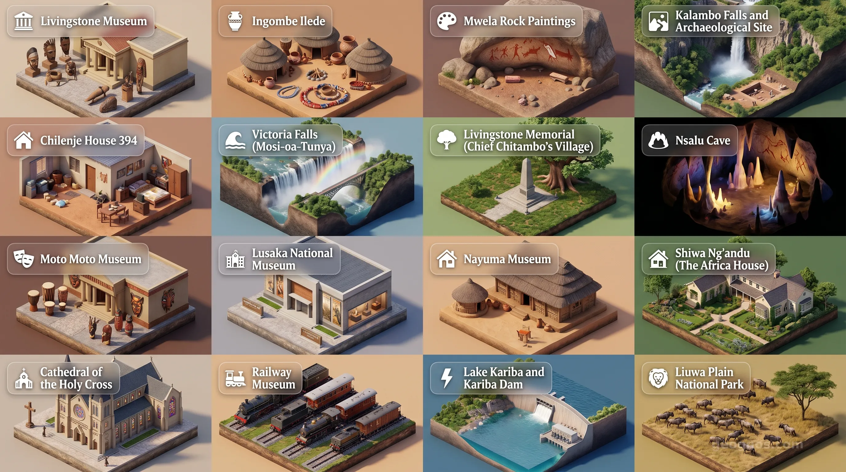
Zambia - Panoramic Places of Interest Atlas including Livingstone Museum, Ingombe Ilede, Mwela Rock Paintings, Kalambo Falls and Archaeological Site, Chilenje House 394, Victoria Falls (Mosi-oa-Tunya), Livingstone Memorial (Chief Chitambo's Village), Nsalu Cave, Moto Moto Museum, Lusaka National Museum, Nayuma Museum, Shiwa Ng'andu (The Africa House), Cathedral of the Holy Cross, Railway Museum, Lake Kariba and Kariba Dam, Liuwa Plain National Park

Top Sights & Landmarks

01

Livingstone Museum

Zambia's Oldest and Largest Museum

02

Ingombe Ilede

Ancient Trade Hub of the Zambezi

03

Mwela Rock Paintings

Extensive Stone Age Rock Art

04

Kalambo Falls and Archaeological Site

Ancient Habitation and Towering Falls

05

Chilenje House 394

Birthplace of Zambian Independence

06

Victoria Falls (Mosi-oa-Tunya)

The Smoke That Thunders

07

Livingstone Memorial (Chief Chitambo's Village)

Resting Place of Livingstone's Heart

08

Nsalu Cave

Ancient Geometric Rock Art

09

Moto Moto Museum

Cultural Hub of the Bemba People

10

Lusaka National Museum

Zambia's National History and Art

11

Nayuma Museum

Preserving the Lozi Heritage

12

Shiwa Ng'andu (The Africa House)

A Slice of England in the African Bush

13

Cathedral of the Holy Cross

Icon of Modernist Unity

14

Railway Museum

Industrial History of Livingstone

15

Lake Kariba and Kariba Dam

World's Largest Man-Made Reservoir

16

Liuwa Plain National Park

Historic Conservation and Vast Plains

The Roaring Heart of the Plateau

To stand upon the banks of the Zambezi, near the threshold where the earth seemingly splits asunder, is to witness the true character of Zambia. Here, the Mosi-oa-Tunya, or the Smoke that Thunders, serves as more than a geographic landmark. It is the rhythmic heartbeat of a nation defined by its vast, elevated plateaus, its life-sustaining rivers, and its transition from a quiet wilderness of the savanna to a vital anchor of Southern Africa. Zambia does not merely exist within its borders. It stretches outward as a cradle of humanity and a mosaic of biodiversity that has, for millennia, shaped the movements and traditions of the people who call this land home.

Unlike its neighbors who may look toward the ocean, Zambia is an introspective nation, landlocked yet defined by the fluidity of its inland seas and arterial waterways. This is a land of wide horizons where the sky touches the grass with an intimacy rarely found elsewhere. To understand Zambia, one must look beyond the spectacle of its waterfalls and delve into the human narrative that has etched itself into the iron-rich soil. We invite you to explore the history of Zambia, where every migration and settlement tells the story of resilience and ingenuity on the Central African plateau.

A Tapestry Woven from Rivers and Plains

The geography of Zambia is often described as a plateau that slopes gently toward the south and east. It is a land shaped by the forces of water. From the mighty Zambezi to the Kafue and the Luangwa, these rivers have acted as conduits for culture and commerce, drawing civilizations to their fertile basins. These waterways are not merely natural features. They are the architects of the landscape, cutting deep gorges into the limestone and creating sprawling floodplains that provide refuge for one of the largest migrations of mammals on the planet.

When studying these terrains, students and historians often find it challenging to mentally map the evolution of the various kingdoms and societal shifts that occupied these floodplains. To aid in this journey of discovery, we have developed a resource for you to test your knowledge. You can challenge yourself with our history puzzle, an interactive experience that requires you to place the pivotal moments of Zambian development in their proper chronological sequence to unlock academic achievement badges.

The Living Museum of the Wild

While the geography dictates the economic path of the nation, it is the spectacular intersection of flora and fauna that defines the Zambian spirit for the visitor. The protected wilderness areas here remain some of the last bastions of true wilderness in the world. It is a realm where the distinction between humanity and nature is intentionally blurred, favoring conservation and coexistence. Whether you are observing the elephants navigating the shifting sands of the riverbanks or tracking the apex predators of the Luangwa Valley, the immersion is absolute.

Visualizing these spaces before one arrives is an essential part of the travel experience, especially for educators planning their next unit on African ecosystems. To witness the vibrant beauty of this terrain, we suggest you peruse our POI cinematic showcase, a collection of curated images that capture the sheer scale and majesty of Zambia's most treasured landmarks. Through these high-definition vignettes, the distant roar of the falls and the stillness of the mopane forests become tangible.

The Echoes of Centuries Past

Zambia's narrative is a layering of cultures. It is the story of the Bantu migrations, the iron-smelting pioneers, the explorers who mapped the confluence of rivers, and the vibrant modern nation that embraces its multi-ethnic heritage. Each chapter of this chronicle remains visible today in the traditional ceremonies held in the various provinces, where the rhythms of drums still celebrate the history of chiefs and ancestors. These rituals act as living archives, preserving the memory of the past in the face of rapid modern growth.

Understanding these historical layers requires a dynamic approach to learning, where the static text of a textbook meets the immersive potential of digital media. For those who seek a deeper emotional connection to the individuals and events that transformed this territory into the Zambia we recognize today, we offer a history cinematic showcase. This carousel takes the viewer through the transformative eras of the region, utilizing archival-style illustrations and rigorous summaries to bring history to life in a way that respects both the academic and the awe-inspiring elements of the human experience.

Looking Forward from the Heart of Africa

As we document the progress of Zambia at GeoGnos.com, we recognize that the nation stands at an intriguing intersection of heritage and innovation. It is a country that prizes its historical continuity while simultaneously reaching toward a future defined by infrastructure development and ecological sustainability. The people of Zambia are characterized by a profound warmth and a resilient spirit, a demographic vitality that sees young generations actively participating in the shaping of their political and environmental destiny.

The journey through Zambia is, above all, a journey of connection. Whether you are walking through the busy markets of Lusaka, participating in the Kuomboka ceremony along the Barotse floodplain, or simply tracing the blue lines of the rivers on a map, you are engaging with a vital part of the global collective. We hope this introduction serves as a bridge, bringing you closer to the soul of a nation that remains, in every sense, the roaring heart of the African plateau.
Location

Latitude
-15° N
Longitude
30° E
N S W E
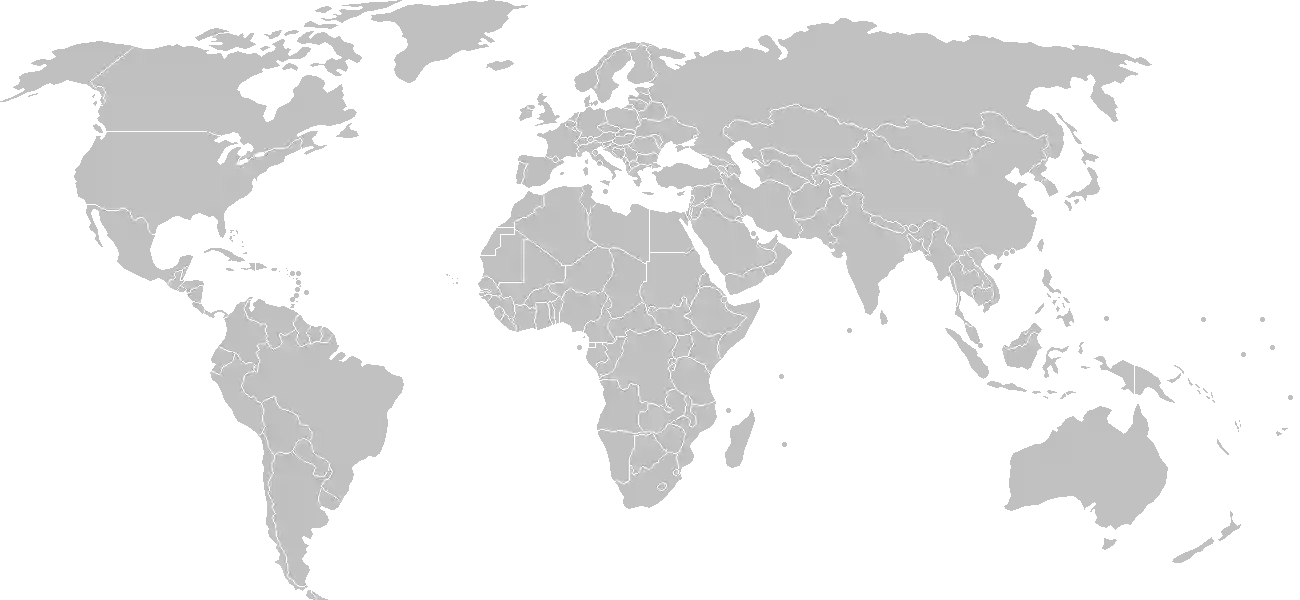
World Map Location
Geographic Location

Southern Africa, east of Angola, south of the Democratic Republic of the Congo

Map Reference
Africa

Area

Total Area
752,618 sq km
Land (99%)
Land: 743,398 sq km
Water: 9,220 sq km

Elevation

Highest Point
Mafinga Central
Mafinga Central 2,330 m
Lowest Point
Zambezi river
Zambezi river 329 m
Mean Elevation
1,138 m

Detailed Geography Information

Coastline

0 km (landlocked)

Geography - note

landlocked; the Zambezi forms a natural river boundary with Zimbabwe; Lake Kariba on the Zambia-Zimbabwe border forms the world's largest reservoir by volume (180 cu km; 43 cu mi)

Irrigated land

1,560 sq km (2012)

Land boundaries

Total boundary: 6,043.15 km
Angola 1065 km
Botswana 0.15 km
Malawi 847 km
Mozambique 439 km
Namibia 244 km
Tanzania 353 km
Zimbabwe 763 km

Major aquifers

Upper Kalahari-Cuvelai-Upper Zambezi Basin

Major lakes (area sq km)

fresh water lake(s): Lake Tanganyika (shared with Democratic Republic of Congo, Tanzania, and Burundi) - 32,000 sq km; Lake Mweru (shared with Democratic Republic of Congo) - 4,350 sq km; Lake Bangweulu - 4,000-15,000 sq km seasonal variation

Major rivers (by length in km)

Congo river source (shared with Angola, Republic of Congo, and Democratic Republic of Congo [m]) - 4,700 km; Zambezi river source (shared with Angola, Namibia, Botswana, Zimbabwe, and Mozambique [m]) - 2,740 km note: [s] after country name indicates river source; [m] after country name indicates river mouth

Major watersheds (area sq km)

Atlantic Ocean drainage: Congo (3,730,881 sq km) Indian Ocean drainage: Zambezi (1,332,412 sq km)

Maritime claims

none (landlocked)

Natural hazards

periodic drought; tropical storms (November to April)

Natural resources

coppercobaltzincleadcoalemeraldsgoldsilveruraniumhydropower

Terrain

mostly high plateau with some hills and mountains

Population & Growth

+2.50% Growth
22,021,971
Total inhabitants (2025 est.)
Male: 50.3% (11,066,079) Female: 49.7% (10,955,892)

Age Distribution

0-14 years
42.1%
~9,271,250
15-64 years
55.1%
~12,134,106
65 years
2.8%
~616,615
Note: 2024 est.

Demographic Longevity

Median Age
19 years
Male
18.2 yrs
Female
18.6 yrs
Life Expectancy
66.9 years
Male
65.2 yrs
Female
68.7 yrs

Vital Dynamics

Birth Rate
29.6
births per 1,000 people
Death Rate
4.91
deaths per 1,000 people
Net Migration
+0.4
migrants per 1,000 people
Fertility Rate
3.67
children born per woman

Detailed People & Society Information

Alcohol consumption per capita

3.82 liters of pure alcohol (2019 est.)

Children under the age of 5 years underweight

11.8% (2018 est.)

Currently married women (ages 15-49)

55.7% (2018 est.)

Dependency ratios

total dependency ratio: 75.8 (2025 est.) youth dependency ratio: 71.3 (2025 est.) elderly dependency ratio: 4.5 (2025 est.) potential support ratio: 22.3 (2025 est.)

Education expenditure

4.1%

4.1% of GDP (2023 est.) 14.5% national budget (2025 est.)

Ethnic groups

Bemba
21%
Tonga
13.6%
Chewa
7.4%
Lozi
5.7%
Nsenga
5.3%
Tumbuka
4.4%
Ngoni
4%
Lala
3.1%
Kaonde
2.9%
Namwanga
2.8%
Lunda
2.6%
Mambwe
2.5%
Luvale
2.2%
Lamba
2.1%
Ushi
1.9%
Lenje
1.6%
Bisa
1.6%
Mbunda
1.2%
other
13.8%
unspecified
0.4%

Gross reproduction rate

1.81 (2025 est.)

Health expenditure

6.6%

6.6% of GDP (2021) 8.9% of national budget (2022 est.)

Infant mortality rate

total: 30.1 deaths/1,000 live births (2025 est.) male: 38.9 deaths/1,000 live births female: 32.1 deaths/1,000 live births

Languages

Bemba
33.4%
Nyanja
14.7%
Tonga
11.4%
Lozi
5.5%
Chewa
4.5%
Nsenga
2.9%
Tumbuka
2.5%
Lunda
1.9%
Kaonde
1.8%
Lala
1.8%
Lamba
1.8%
English
1.7%
Luvale
1.5%
Mambwe
1.3%
Namwanga
1.2%
Lenje
1.1%
Bisa
1%
other
9.7%
unspecified
0.2%

Literacy

total population: 71.1% (2018 est.) male: 81.7% (2018 est.) female: 62.2% (2018 est.)

Major urban areas - population

3.181 million LUSAKA (capital), 763,000 Kitwe (2023)

Maternal mortality ratio

85 deaths/100,000 live births (2023 est.)

Mother's mean age at first birth

19.2 years (2018 est.) note: data represents median age at first birth among women 20-49

Nationality

noun: Zambian(s) adjective: Zambian

Obesity - adult prevalence rate

8.1% (2016)

Physician density

0.32 physicians/1,000 population (2022)

Population distribution

one of the highest levels of urbanization in Africa; high density in the central area, particularly around the cities of Lusaka, Ndola, Kitwe, and Mufulira, as shown in this population distribution map

Refugees and internally displaced persons

Total Displaced & Vulnerable Persons
220,267 individuals
Refugees
40.4%
88,918
88,918 (2024 est.)
Internally Displaced Persons (IDPs)
59.6%
131,349
131,349 (2024 est.)

Religions

Protestant
75.3%
Roman Catholic
20.2%
other (includes Muslim
2.7%
none
1.8%

Sex ratio

at birth: 1.03 male(s)/female 0-14 years: 1.02 male(s)/female 15-64 years: 1 male(s)/female 65 years and over: 0.82 male(s)/female total population: 1 male(s)/female (2024 est.)

Tobacco use

total: 11.7% (2025 est.) male: 21.4% (2025 est.) female: 2.4% (2025 est.)

Climate & Issues

Climate Profile

tropical; modified by altitude; rainy season (October to April)

Key Environmental Issues
air pollution and acid rain in the mineral extraction and refining region chemical runoff into watersheds loss of biodiversity poaching deforestation soil erosion desertification lack of adequate water treatment

Land Cover

Coverage Distribution
Agri (32%)
Forest (61%)
Arable: 5.1%
Crops: 0.1%
Pasture: 26.9%
Forest: 60.6%

Air & Carbon Emissions

Annual CO2 Output 2023 est.
9.877 million
Coal (49%) Oil (51%) Gas (0%)
PM2.5 Exposure 16.1 µg/m³
0 5 (WHO Limit) 15 25 35+

Water Resources & Use

Renewable Water Resources 104.8 billion cubic meters (2022 est.)
Annual Water Withdrawal
municipal: 290 million cubic meters (2022 est.)
Municipal (18%) Ind (8%) Agri (73%)

Detailed Environmental Information

International environmental agreements

BiodiversityClimate ChangeClimate Change-Kyoto ProtocolClimate Change-Paris AgreementComprehensive Nuclear Test BanDesertificationEndangered SpeciesHazardous WastesLaw of the SeaNuclear Test BanOzone Layer ProtectionWetlands

Urbanization

urban population: 46.3% of total population (2023) rate of urbanization: 4.15% annual rate of change (2020-25 est.)

Waste and recycling

municipal solid waste generated annually: 2.608 million tons (2024 est.) percent of municipal solid waste recycled: 12.6% (2022 est.)

Capital & State Profile

Capital City
Lusaka
-15.4167° N, 28.2833° E
Timezone UTC+2
Government Type
presidential republic
Independence 1964-10-24
National Holiday 10-24

Executive Branch

Chief of State
President Hakainde HICHILEMA (since 24 August 2021)
Head of Government
President Hakainde HICHILEMA (since 24 August 2021)
Last Election 12 August 2021
Next Election 2026
Cabinet Cabinet appointed by president from among members of the National Assembly

Legislative Branch

unicameral
Legislature Name National Assembly
Seats & Term
167 (156 directly elected; 8 appointed) seats / 5 years
Women in Chamber
15% Representation
Electoral System plurality/majority
Parties Composition
United Party for National Development (UPND) 82Patriotic Front (PF) 60Independents 13Other 1

National Identity & Symbols

National Flag Description

green field with a soaring orange eagle in the upper-right corner; a panel of three vertical bands is under the eagle, in red (left side), black, and orange

Symbolic Meaning green stands for the country's natural resources and vegetation, red for the struggle for freedom, black for the people, and orange for the country's mineral wealth; the eagle represents the people's ability to rise above the nation's problems
National Symbol African fish eagle
National Colors green, red, black, orange
National Anthem Lumbanyeni Zambia (Stand and Sing of Zambia, Proud and Free)

Detailed Government Information

Administrative divisions

10 provinces; Central, Copperbelt, Eastern, Luapula, Lusaka, Muchinga, Northern, North-Western, Southern, Western

Citizenship

citizenship by birth: only if at least one parent is a citizen of Zambia citizenship by descent only: yes, if at least one parent was a citizen of Zambia dual citizenship recognized: yes residency requirement for naturalization: 5 years for those with an ancestor who was a citizen of Zambia, otherwise 10 years residency is required

Constitution

history: several previous; latest adopted 24 August 1991, promulgated 30 August 1991 amendment process: proposed by the National Assembly; passage requires two-thirds majority vote by the Assembly in two separate readings at least 30 days apart; passage of amendments affecting fundamental rights and freedoms requires approval by at least one half of votes cast in a referendum prior to consideration and voting by the Assembly

Country name

conventional long form: Republic of Zambia conventional short form: Zambia former: Northern Rhodesia etymology: name is derived from the Zambezi River, which flows through the western part of the country and forms the southern border with Zimbabwe

International law organization participation

has not submitted an ICJ jurisdiction declaration; accepts ICCt jurisdiction

International organization participation

Judicial branch

highest court(s): Supreme Court (consists of the chief justice, deputy chief justice, and at least 11 judges); Constitutional Court (consists of the court president, vice president, and 11 judges) judge selection and term of office: Supreme Court and Constitutional Court judges appointed by the president of the republic upon the advice of the 9-member Judicial Service Commission, which is headed by the chief justice, and ratified by the National Assembly; judges normally serve until age 65 subordinate courts: Court of Appeal; High Court; Industrial Relations Court; subordinate courts (3 levels, based on upper limit of money involved); Small Claims Court; local courts (2 grades, based on upper limit of money involved)

Legal system

mixed system of English common law and customary law

National heritage

total World Heritage Sites: 1 (natural) selected World Heritage Site locales: Mosi-oa-Tunya/Victoria Falls

Political parties

Alliance for Democracy and Development or ADD Forum for Democracy and Development or FDD Movement for Multiparty Democracy or MMD Party of National Unity and Progress or PNUP Patriotic Front or PF United Party for National Development or UPND

Suffrage

18 years of age; universal

Economic Overview

lower-middle-income sub-Saharan economy; regional hydroelectricity producer; trade ties and infrastructure investments from China; IMF assistance to restructure debt burden; one of youngest and fastest-growing labor forces; systemic corruption; extreme rural poverty

Size & Performance

Real GDP (PPP)
$79.207 billion
Latest available estimate (2024)
2023: $76.129 billion2022: $72.251 billion
Real GDP Growth
4% (2024 est.)
+4%
GDP Per Capita (PPP)
$3,700
2023: $3,7002022: $3,600

GDP Sector Breakdown

Agriculture: 1.8%Industry: 37.5%Services: 55.1%
Origin GDP %
Agriculture 1.8%
Industry 37.5%
Services 55.1%

Trade Balance

Trade Position
Trade Surplus
$600.00 million
Total Exports
$11.454 billion (2023 est.)
Total Imports
$10.854 billion (2023 est.)
Exports (51%) Imports (49%)

Budget Balance

Budget Position
Budget Deficit
-$802.00 million
Revenues
$5.388 billion (2021 est.)
Expenditures
$6.19 billion (2021 est.)
Revenues (47%) Expenditures (53%)

Export Profile

Top Export Partners

15.0%
13.0%
12.0%
10.0%
Note: 2023; top five export partners based on percentage share of exports

Major Export Commodities

raw copperrefined coppergoldprecious stoneselectricity

Import Profile

Top Import Partners

Note: 2023; top five import partners based on percentage share of imports

Major Import Commodities

refined petroleumfertilizerstruckssulphurtractors

Labor & Employment

Total Labor Force 7.407 million (2024 est.)
General Unemployment Rate 6%
Youth Unemployment (Ages 15-24) 9.9%
Population Below Poverty Line 60% (2022 est.)

Income Inequality

Gini Coefficient (Family Income) 51.5
0 (Perfect Equality) High Inequality 100 (Perfect Inequality)

Family Income / Consumption Share

Lowest 10%: 1.5% (2022 est.) Highest 10%: 39.1% (2022 est.)
Inequality Gap: Top 10% holds 26.1x the share of the bottom 10%.

Detailed Economic Data

Agricultural products

sugarcanecassavamaizesoybeansmilkvegetableswheatgroundnutssweet potatoesbeef

Current account balance

-$582.715 million (2023 est.) $1.093 billion (2022 est.) $2.63 billion (2021 est.) note: balance of payments - net trade and primary/secondary income in current dollars

Debt - external

$16.597 billion (2023 est.) note: present value of external debt in current US dollars

Exchange rates

Zambian kwacha (ZMK) per US dollar - Exchange rates: 26.166 (2024 est.) 20.212 (2023 est.) 16.938 (2022 est.) 20.018 (2021 est.) 18.344 (2020 est.)

GDP - composition, by end use

Industrial production growth rate

3.5% (2024 est.) note: annual % change in industrial value added based on constant local currency

Industries

copper mining and processingemerald miningconstructionfoodstuffsbeverageschemicalstextilesfertilizerhorticulture

Inflation rate (consumer prices)

15% (2024 est.) 10.9% (2023 est.) 11% (2022 est.) note: annual % change based on consumer prices

Public debt

71.4% of GDP (2021 est.) note: central government debt as a % of GDP

Remittances

0.9% of GDP (2023 est.) 0.8% of GDP (2022 est.) 1.1% of GDP (2021 est.) note: personal transfers and compensation between resident and non-resident individuals/households/entities

Reserves of foreign exchange and gold

$3.173 billion (2023 est.) $2.968 billion (2022 est.) $2.754 billion (2021 est.) note: holdings of gold (year-end prices)/foreign exchange/special drawing rights in current dollars

Taxes and other revenues

16.8% (of GDP) (2021 est.) note: central government tax revenue as a % of GDP

Grid Infrastructure

Electricity Access 47.8%
Urban: 87% Rural: 14.5%
Capacity 3.986 million kW (2023 est.)
Consumption 14.399 billion kWh (2023 est.)
Exports 3 billion kWh (2023 est.)
Imports 180 million kWh (2023 est.)
Grid Losses: 2.229 billion kWh (2023 est.)

Generation Mix

Percentage Share of Production
hydroelectricity 87.9%
fossil fuels 11%
solar 0.8%
biomass and waste 0.4%

Fossil Fuels Production

Petroleum
Consumption 34,000 bbl/day (2023 est.)
Coal
Production 2.091 million metric tons (2023 est.)
Consumption 2.081 million metric tons (2023 est.)
Exports 15,000 metric tons (2023 est.)
Imports 103,000 metric tons (2023 est.)
Proven Reserves 945 million metric tons (2023 est.)

Intensity & Nuclear

Energy Consumption Per Capita 8.265 million Btu/person (2023 est.)
No nuclear energy infrastructure or reactor operations reported in this country dossier.

Digital Access

.zm
Internet Usage 33%

Active internet users as a percentage of the total population.

Fixed Broadband

Penetration Rate 0 / 100
Total Subscriptions 99,000 (2023 est.)

Mobile Cellular

Penetration Rate 109 / 100
Total Subscriptions 23.2 million (2024 est.)

Broadcast Media

47 state-controlled and private TV stations; state-owned Zambia National Broadcasting Corporation (ZNBC) has 2 TV channels, controls 1, and owns shares in 2 more; 137 radio stations, with 133 private and 4 state-owned (2019)

Aviation

9J
Airports
120
As of 2025
Heliports
4
As of 2025

Railways

Total Track Length
3,126 km
National Network Data from 2014

Merchant Marine

Commercial Fleet
2 ships
Hover for vessel types breakdown As of 2023

Military Expenditures

GDP Allocation 1.3%
1.3% of GDP (2024 est.) 1.3% of GDP (2023 est.) 1.1% of GDP (2022 est.) 1.1% of GDP (2021 est.) 1.2% of GDP (2020 est.)

Active Duty Strengths

approximately 16,000 active Defense Forces (2025)

Refers to active military personnel.

Service & Defense Details

Military and security forces

Zambia Defense Force (ZDF): Zambia Army, Zambia Air Force, Zambia National Service Ministry of Home Affairs and Internal Security: Zambia Police (2025) note 1: the Zambia National Service is a support organization that also does public work projects; its main objectives revolve around land development, agriculture, industries, youth skills training as well as arts, sports and culture; the ZDF also includes a Defense Force Medical Service note 2: the Zambia Army comprises the Regular Force, the Home Guard, and the Territorial Reserve

Military deployments

930 Central African Republic (MINUSCA) (2025)

Military equipment inventories and acquisitions

the ZDF's inventory is largely comprised of Chinese, Russian, and Soviet-era weapons and equipment along with smaller quantities of items from other suppliers such as Israel, South Africa, and the US (2025)

Military - note

the Zambia Defense Forces (ZDF) are responsible for territorial defense, border security, and providing support to African and UN peacekeeping operations; it also has some domestic security responsibilities in cases of national emergency and is involved in socio-economic support; in recent years, ZDF has been directed to assist in agricultural production; the ZDF is part of the Southern Africa Development Community (SADC) Standby Force and participates in multinational training exercises; it has received training assistance from China and the US the ZDF traces its roots to the Northern Rhodesia Regiment, which was raised by the British colonial government to fight in World War II; the ZDF was established in 1964 from units of the dissolved Federation of Rhodesia and Nyasaland armed forces; it participated in a number of regional conflicts during the 1970s and 1980s; Zambia actively supported independence movements such as the Union for the Total Liberation of Angola (UNITA), the Zimbabwe African People's Union (ZAPU), the African National Congress of South Africa (ANC), and the South-West Africa People's Organization (SWAPO) (2025)

Military service age and obligation

18-25 years of age (17 with parental consent) for voluntary military service for men and women; no conscription; initial service of 7 years followed by 5 in the Reserves (2025)